|
Special Features
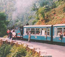
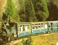
Darjeeling Himalayan Railways |
|||||
With the fanfare of worldwide publicity, the Darjeeling Himalayan Railway (DHR) was reborn when it was finally recognised as a heritage railway by the UNESCO. Senior officials of the Government of India, UNESCO, railway authorities and politicians of stature all turned up in the hills of Darjeeling for the inaugural occasion. A marble tablet commemorating the occasion was laid at the quarter angle of the Darjeeling Sadar Railway station. Railway officials expressed satisfaction that their hard work in seeking recognition had at long last been rewarded. |
Passage to India • Overview • History • Time Periods • Dateline of Events • Geography • Economy • Polity • Religion • Festivals • Languages • Dress • Travel Tips • Special Features |
||||
 Yet, just a few decades ago, the Indian Railway had decided to do away with DHR as it was no longer commercially viable and therefore on the verge of extinction. Pressure, particularly from DHR fans in the United Kingdom, led the Government of West Bengal to urge the Railways to preserve the train on the plea that it was important for the promotion of tourism. The result was UNESCO's decision to inscribe DHR on its prestigious list of World Heritage Sites. Souvenirs and commemorative model items of toy train locomotives and specially designed neckties were made to fit the occasion. The Postal Department was not far behind when it issued a commemorative stamp of the toy train winding its way on to the Batasia loop.
 It was, however, ironic that the no mention was made of the one person most responsible for the creation of the "marvel toy train". The man who made the completion of the railways in the sub Himalayan hills possible was an Englishman named Franklyn Prestage, a civil engineer by profession. A few words by way of tribute to him would have been fitting to the occasion, which had merited the attention of the world body of education, science and culture. The train was his brainchild. He laboured for decades on design, layout of the track and all the nitty gritty in great detail. It has to be appreciated that working conditions at that time were much tougher and to enable him to remain compltelely absorbed in the project and to be near the site, he shifted his residence and lived in a house known as Ivanhoe in Darjeeling around 1865. The house became the drawing board and control room of the proposed railways. In his honour, Darjeeling Municipality, which is the oldest in the country, named the road adjoining Ivanhoe "Dr. Franklyn Prestage Road". Ivanhoe and the road still continue today by the same name, although a very few seem to be aware of the origins of the name. Recognition of Franklyn Prestage's engineering talent, so aptly demonstrated by the success of the completion of the railways in the hills, resulted in the conferment upon Prestage of a doctorate degree of engineering by a University in Great Britain.
The origins of DHR lie in a decision taken by the Board of East Bengal State Railways for a reliable means to transport tea from Darjeeling to the plains and thence on to Calcutta Port. Land recently "acquired" from the "Rajah of Shikkim" would be used for this purpose. Tea plantations by then appeared promising for successful future development in the Darjeeling hills, besides which there was timber. The railway construction was entrusted to Franklyn Prestage who was then the Agent of the East Bengal State Railways.
Numerous consultations with engineers of Glasgow Locomotive Co., which designed and supplied special steam locomotives, and with the engineers, Messrs. Guindt Arbathadt & Co. took place. This civil engineering and construction company was believed to be an Anglo/Scottish/Armenian company based in Calcutta. Armenians had long had their presence in Calcutta much earlier to the English East India Co. A series of discussion took place whether to have the track laid on the normal route, then known as the "Old Military Road", or to chart out an entirely new route. It may be recalled that the "old military road" came to be known by that name because it was the route taken by the first batch of British soldiers sent on a punitive raid against the "Rajah of Shikkim" for the imprisonment of two English botanists. The two botanists, who had strayed into Sikkimese territory, were imprisoned and had suffered indignities at the hands of their captors. They were caged in a small bamboo enclosure as was the local practice and human refuse was poured on them. This was an extremely humiliating act for the mighty British Raj, firmly on the ascendancy in India at the time. The Governor General in Calcutta decided to teach the "Shikkimese Rajah" a lesson and dispatched a contingent of British soldiers. However, when soldiers reached the fringes of the Sikkimese border near today's Naxalbari they appear to have got lost as beyond this point their military map was blank. With the help of some Sikkimese people who knew the terrain well the British contingent was led to climb straight uphill in the northerly direction. It managed to reach the upper ridge of today's Kurseong on top of Dowhill and finally reached Singchel near today's Ghoom after traversing through dense pinewood and rhododendron forests. This road still exists although four-wheel drive and smaller vehicles prefer to use a half portion of this route from Kurseong-Pankkhabari to the "plains" which is shorter and more time saving. The upper ridge road still exists almost in its original form with contours and numerous short and sharp turnings. It winds through the pine and rhododendron forest. This portion is now the preserve of the State Forest Dept. and the Indian Air Force (IAF), which is believed to have installed a radar centre there after the war with China in 1962. The second option before Franklyn Prestage was to bore tunnels from an area known as "Dudhyaa" almost at mean sea level from the opposite side of a river known as "Balasone" which flows through the hills to the plains. This plan envisaged that the end of the tunnel would emerge at around Senchel forest area near present day Ghoom. Consultations with geologists in the UK led to the conclusion that the rock content and formation were "malleable", requiring extraordinary reinforcement of the tunnel wall, ceiling and base. The tunnel proposition was then dropped, as the cost of construction would be prohibitive. Prestage decided in favour of the conventional technique of forging railway track through the hills. Foremost in his mind was the need to cut the stiff slope into a gradual gradient. This required the railway route to wind through the hills to the far stretch and with a U-turn detour to achieve gradual height. This technique was incorporated in the first sector of the construction between the Gayabari-Mahanadi and Rangtang-Tindharia sub-sectors. It would be not out of place to mention that some affluent Sikkimese and Bhutanese families purchased a good amount of real estate in areas that they thought was where the railway track would pass in the hope that the value of this land would then shoot up. Eventually, these areas fell far off the actual railway track. Descendants of one such family still own a good portion of land that has no commercial value at all even in today's market! A blue print was finally laid and approved. The railways would have a total distance of 51.50 miles (82.89 kms) and traverse through hitherto uncharted "foothills" area of dense tarai Sal forest and gradually make its way up the hills in a negotiable gradient. The "narrow gauge" line of 0.610 Mts. would begin at Siliguri and finally end at Darjeeling. The operational part would be divided into four sectors. The first would commence from Siliguri and end at Kurseong; the second from Kurseong to Sonada; the third from Sonada to Ghoom; and lastly from Ghoom to Darjeeling. However, the construction was carried out more or less simultaneously in all the four sectors.
First Sector The greatest challenge to the construction work faced was in the terai region due to a widespread though less known tropical disease. The disease came to be known as "Kalazar" which was widespread in epidemic form. It imposed a heavy toll on the lives of the "coolies" who were mainly from the eastern hills of Nepal. These Nepalese hill men were attracted by the high wages of an anna (4 paisa) per person per day. As the hill people never had experienced Kalazar, coolies died by the hundreds, thus placing the project in serious jeopardy. This was a bad beginning and there was fear that the construction would be considerably delayed or even be postponed indefinitely till some measure to counter the menace of kalazar was found. The world had not yet discovered quinine nor heard of Alexander Fleming. The difficulty was overcome eventually by the ingenuity of English supervisors. It was discovered that unlike the hill people of Nepalese stock who were highly susceptible to kalazar some native tribesmen of the terai area known as the Tharoos, Kochmoch etc had far greater resistance to the disease. The natives replaced the hill men. Thereafter, the construction continued apace through the terai area up towards the hills without the risk of disease. The First phase was completed on 23rd August 1880. There was an interesting and humorous episode. The First Lady, the Vicerene of India and her entourage were the honoured passengers. At the zigzag point near Chunbati station, the train proved to be beyond the power of the two narrow gauge locomotives. Bullocks and "coolies" by the hundreds had to literally push and pull the train to the higher level. The cause of loss of inertia was later discovered to be the large number of extra heavy luggage of the First Lady!
Second Sector
Third Sector
Fourth Sector A further extension of track was laid from the Darjeeling Sadar Railway station to the main warehouse to the heart of Darjeeling town popularly known as the "Mal Godown". This was used only by goods trains to offload cargo and for distribution to consignees. Unfortunately, the steel tracks and sleepers have all been uprooted and have vanished. Massive buildings have been constructed on the property of the Railways.
Siliguri/Sevoke/Tista Section A journey through this sector of track is an unimaginably delightful experience with breathtaking scenery of vertical hills rising from almost sea level to 12000 ft on the one side and the river Teesta flowing parallel to the track through thick tropical Sal forest, on the other. The journey is reminiscent of the journey through the Canadian Rockies to Vancouver. It ends at the Rungli Rangliot Station near Teesta town. Unfortunately, the great landslides of 1950's devastated many places and caused widespread damage to property and life. The DHR was no exception. Extensive damage was caused and large portions of the railway track were washed out and fell into the Teesta river. Repairs and restoration of the track involved a huge sum. Sadly, the Railway authorities, lacking foresight, at least from the heritage point of view, decided to disband and close this sector forever. It left only a handful of old timers to retain nostalgic memories of the Siliguri-Sevoke-Tista sector of DHR, abandoned and heaped in the river Teesta by the Railway mandarins in New Delhi. |
|||||
Editor: Romola Butalia (c) India Travelogue. All rights reserved. |
|||||