| Mountaineering
A Mysterious Pass Amidst the Clouds
|
|||||||||||||||||||||
"We are in love with each other - ~ Li Tao Po It was the beginning of yet another summer and another call from the mountains. Sitting in a humid Delhi office I was toying with the idea of planning an elaborate expedition while scanning the pages of Indian Mountaineer # 25 when a feature on Dhumadhar Kandi Pass caught my attention. Reading the article over and over, I was transported to the inner sanctum of the Himalayas, treading the unknown wonderland, exploring and enjoying the closeted beauty of Mother Nature. The more I read the accounts of earlier expeditions, the nearer I reached to the idea of visiting the Banderpoonch area. In 1815, J.B Fraser, on his way to Gangotri collected information about Dhumadhar Pass. From his "Journal of Himalayan Travel" we came to learn that Sian Gad, a tributary, which meets Bhagirathi from the north-west near Harsil village, rises in Dhumadhar - a very lofty and wild range to the north of Banderpoonch , along which there is an alarming road leading to remote parts of Rawaeen. |
More on Uttarakhand • An Overview
Mountaineering
Adventure
Travelogues | ||||||||||||||||||||
In those ancient days, the villagers and traders used to cross this pass from Sian valley to arrive at the villages in the valley of Kinnaur by crossing the easier Borasu Pass, 5151m, bordering Uttarkashi in U.P., and Kinnaur in H.P.
In the recent past a team from Calcutta, led by Amulya Sen in 1972, made the first known attempt to Dhumadhar Pass. From Seema (Osla) they made five camps and launched an attack on the second part of the ridge close to Yellow Tooth. Inclement weather and poor snow conditions foiled their attempt. Next year a small team, also from Calcutta, led by Sudhan Bose attempted the same part of the ridge. The leader met with an accident and was badly injured. Two members and porters of the team claimed to have reached the Pass (an account appeared in Himavanta -March '74) but faced severe criticism as the 'account is by no means convincing' (Himavanta May '74).
The third recorded attempt was in 1984 by a two-member team composed of S. S. Mukherjee and G. Santra also from West Bengal, from the reverse direction (Himavanta, March '85 and Indian Mountaineer, Spring '87). From the confluence of Sian and Gantraro Gads, they followed a tributary to the southwest to arrive at a glaciated field below the watershed. They finally gained the ridge keeping close to Yellow Tooth and planted a rectangular slate stone on the 'depression' as evidence of their crossing. They descended along an eighty degree snowy scree slope which they thought to be the 'only feasible route' to the Tons (Ruinsara) valley".
The initial plan was to approach the peak and the pass from the normal western side of Tons Valley through Sankri, Osla, Ruinsara Tal and Swargarohini base. Our arrival in Uttarkashi and a final rerun of the plans shifted our attention from the western to the eastern side of the pass/peak. The reasons were many -the paucity of time, shorter approach, reaching the peak and the pass fresher than by the very long march from the western end - and most importantly, being able to explore the route from eastern side since not much was known about the area.
We decided to embark from Jhala, a little hamlet about 50 km short of Gangotri. With the help of local friends and well wishers, we gathered essentials and organised a happy-go-lucky team of porters and a guide at Uttarkashi, in about two days. We deeply missed our friend, Himalaya Sherpa (a great guide and an excellent climber) who was with another expedition in Gangotri area. On September 4 we left Uttarkashi for Jhala.
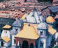
Numerous cups of tea and pakoras lifted our spirits. By then it was clear that we would have to spend the night at Jhala. We decided to drop the porters at Jhala and proceeded to Gangotri to spend the night there and come back the next morning after offering prayers at the Gangotri temple.
It was 10 am by the time we left Jhala on 5th September. We could hear conch shells and bells announcing the puja preparations for the village deity. We crossed the village and proceeded. For the next few days we walked along Sian and the rocky terrain to its right. From here we had a steep 2500-ft climb at an angle of 75 to 80 degrees. The past days of rain had covered it with moss, tall grass and thick bushes. However, there were good footholds.
Reaching the final bend on the ridge we had a last look at Bhagirathi valley and slowly descended into the narrow Sian Gad gorge. The climb up, though steep and tiring, wasn't as dangerous as the descent over a very narrow rock face which at times was less than 8 inches with a sheer drop of over 2000 ft. The algae and wet growth was slippery because of constant dripping from the ledges overhead. One mistake or a wrong footing would have plunged us into the abyss.
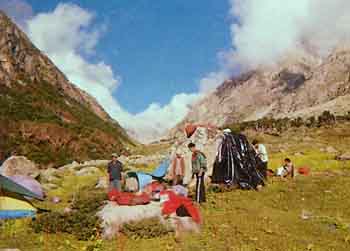
Once through the rocky area we came upon dense grass, at times over seven feet high, which blocked a view of the route ahead. This had accumulated a lot of water and we were drenched walking through. The climb now wasn't steep and we had done almost 9 km when there was a heavy downpour. We spotted lightning through the dense jungle on our left. We found some relief under the sole Bhoj tree that stood in a little clearing. We were wet, cold and tired but a search for a suitable camping area proved unsuccessful. A small clearing was made in mud puddles and soaking ringal grass (a thin bamboo like growth) and we were forced to camp in the filthy surroundings full of mosquitoes and other insects. Pitching a single tent all of us huddled in. That night it rained non-stop and we couldn't sleep a wink, as our sleeping bags were soaked.
On 6th morning there were dense black clouds all over, it was raining and there was no sign of the sun. So we had an extended breakfast. By 11 the rain had nearly stopped, and we moved. The track was as before with slippery mud deposits on rock faces, thorny bushes, tall grass and the constant fear of falling rock because of the rain. It started pouring again and was windy and getting very cold. Soaked clothes and equipment added to the weight. Even in the small streams the water level had increased such that it was difficult to ford them. At three in the afternoon we decided to halt at a point called Talla (lower) Kiyarkoti.
Our campsite was much better in open ground close to a stream in a thick Bhoj jungle. By 4:00 p.m. the rain had stopped and the suns rays slowly infused life into us. We lit a campfire and had a sumptuous dinner while drying wet clothes and warming dampened souls. We woke up fresh the next day.
We still had to cross the Sian Gad further up at Malla (upper) Kiyarkoti where two streams coming from the western glaciers of Yellow Tooth and Banderpoonch merge with Sian. The water level had increased drastically and the current was swift. Not wanting to risk crossing the turbulent river we decided to walk, till there was a point where we could ford it. Despite climbing 2000 feet, we did not find a single place.
Further up was the glacier with its moraines and yawing crevasses. After much deliberation we camped at the edge of the glacier. On the next day we would use the forced climb to our advantage by going straight towards the Yellow Tooth glacier instead of descending again. We had done only nine kms. Some villagers call Sian Gad the Jhutthi Nadi (Liar River). They believe the river should be crossed in the space of one breath as it takes very little time for the water level to change. Till late evening we were exploring shallow points and pushing big boulders into the stream in an attempt to create a crossing point.
At 4:00 am on the 8th we were ready to take on the river. The current didn't seem fearsome though the water was ice cold. We roped up cautiously and crossed over. The vegetation was giving way to lichen and high altitude flowers in small hardy bushes. We were walking on moraine and loose rock, and progress was slow. At close to 15000 ft, dry air, lack of oxygen and cold winds were making the task difficult and tiring.
By 2:45 pm we were at a point where the long ridge connecting Banderpoonch to Swargarohini rose in front of us like a wall. Yet tucked away somewhere was the key to the unknown. We decided to camp and plan our attempt to the Pass.
After two attempts, through different routes on loose moraines, we ended up at a massive ice field with gaping crevices all around. Despite having roped up and having climbed 1000 ft over the hard ice field we could not spot a possible depression that could have been crossed. Further ahead the massive ice wall did not provide any route. We started cutting steps slowly over this hard ice. After two hours and about 200 meters of step cutting, we gave up the unrewarding attempt. Without fixing a rope it would not be possible to take the porters and carry the loads any further. We could not have attempted the Pass without them since we had another four days trek ahead.
We decided to descend and attempt the northwestern face to our left. Precious time had been lost and my friend and group leader Govind Pant had broken his ice axe. We started walking up the northwest side but realised that even this was leading in the wrong direction. The hard climb yet again led us to another ridge without any depression in site. We were tired and frustrated but did not want to give up. We decided to make a third attempt towards the western slopes of Dhumadhar, This route seemed very dangerous. We descended almost 2000 feet on loose scree and moraine and then climbed almost 1500 feet in four hours. We were now at about 17500 ft on Dhumadhar and could look across. Facing us on the east was a very deep gorge descending almost vertically, and we could not even figure out the route further on. There was no way we could think of going down. The constant fear of stone hits kept our nerves on edge even on this third attempt, and we decided to descend towards Yellow Tooth. After losing almost 2200 feet we were at a flat, though windy, patch from where we could closely inspect the entire ridge in front of us.
This was a safe place, but the high wind made it difficult to pitch tents and prepare food. We had to melt ice to drink. By the evening we had "recceed" the true passage to the Col and we were sure of making it the next day. The scene in front of us was just amazing, a large crescent of ridge connecting the Yellow Tooth, Kalanag and Bunderpoonch peaks, stretching to the right as far as we could see. In the distance one could faintly spot Sudarshan Peak. All around were scary glaciers. It was a bizarre place. High winds, temperature close to minus 20-degrees and the uneven rocky surface prevented any sleep.
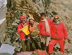
We began at 5 next morning, carefully negotiating the loose rock ledges. There was a constant flow of loose stones from the ridge on our right. Having moved nearly a thousand feet to our left we came to a crater like point from where Yellow Tooth was barely a few hundred feet away from us. The early rays of Sun played their magic on it making it appear molten gold. An azure blue sky devoid of any clouds created a perfect background to the ochre yellow. Another hour of slow climbing towards the ridge and there we were! We were atop the Dhumadhar Kandi Pass. It was precisely 9:38 by our watch.
Standing on the edge of the escarpment ridge overlooking the wall, I recollected the account of JTM Gibson as quoted by Praful Kumar Ganguly in Indian Mountaineer # 25.
"This charming vale is ideal for trekkers and mountaineers where some unclimbed ridges, high passes and virgin peaks still offer challenges. The majestic Swargarohini (6253m), dominating as the highest peak in the range that stretches out from west to east at the northern flank, remains virgin till date and the formidable Dhumadhar Kandi Pass (5608m) on the Tons-Bhagirathi divide at the eastern rim of the valley, has been ever mysterious for its tricky location, dizzy height and unstable weather conditions."
Two days of hard work finally bore fruit when we were ready to begin the descent from the Pass. The loose rocky ridge posed enough danger. Getting down wouldn't be easy since two of our porters started a chain reaction of rolling boulders. The snow field about 200 m down was tempting us - but progress was quite slow. Once near the snowfield we realised what lay ahead- yawning crevices and the long tongue of the glacier.
Thankfully nothing serious or unfortunate happened. We had made the right decision of having approached the Pass from the eastern end since the route ahead had many more problems than anticipated.
The scenario reminded me of the Tibetan plateau to the northeast where similar ranges were slowly crumbling and the rocky terrain was equally risky. From the Banderpoonch base till the Ruinsara Tal along the Banderpoonch Glacier, with Swargarohini hidden to our right, we were walking on almost no track. The path taken by earlier expeditions to Banderpoonch had completely been washed off leaving no trace of the direction to follow. At a lot of places some tricky bends had us clinging to the rock edges and at times brought us on all fours.
Fortunately, the weather gods were in our favour. Slowly trudging the tricky area we reached a safe haven at Deobasa camping ground. The camping ground around Ruinsara Tal and the leftover Bhoj jungle was better than the best alpine meadows. But the porters did not want to camp because a few days ago a climber who had died on Banderpoonch glacier had been buried there. We therefore camped about three kilometres downstream in a makeshift hut built by herb collectors, who would sift through the day's collection here and stay for a few days, before proceeding down to village Osla/Seema. The mystery of Dhumadhar had indeed been unveiled.
Team: Govind Raju (Leader), Rajinder Arora, Jagdish Singh Basera, Laxman Rana and Kamal Sahi.
Assisting porters: Til Bahadur, Kali Bahadur, Nand Bahadur and Nain Bahadur
|
|||||||||||||||||||||
Editor: Romola Butalia (c) India Travelogue. All rights reserved. |
|||||||||||||||||||||

 Beyond the Swargarohini range, Gibson's 'veritable fairyland' - the Har ki Doon exists. This lush green valley is drained by three turbulent streams that combine to form Har ki Doon Nala. The Nala then meets Ruinsara Gad a few kilometres above Osla, the last village of the Upper Tons Valley. These combined streams form the Tons river which continues its journey to join the Yamuna far below near Kalsi.
 At night Gangotri and its surrounding hills have a different magic. The ferocious Bhagirathi prevails - it is music, meditation and noise at the same time. In the filtering moonlight the water-sculpted contours of Gourikund cast their magic. We stood on the bridge mesmerised, before proceeding to Garhwal Mandal rest house. First bus in the morning brought us back to Jhala by 8 am.
 We got to know our porters better and they proved to be a great morale booster. The foursome, all Nepalese, were quite a mixed lot. Til Bahadur, a happy-go-lucky character, and the strongest of them had participated in numerous mountaineering expeditions including Nun-Kun. Nain Bahadur was quiet and a workaholic - you would never see him sitting idle or taking rest. For Nand Bahadur it was his first trek; he had appeared for high school exams in Nepal, and was working to help finance his studies. Kali Bahadur had an unending source of joy and laughter within him. His face was never devoid of a smile, whatever the circumstances.
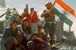 Then cheering, hugging, offering puja, unfurling the tri-colour and singing the national anthem kindled the dying embers of our enthusiasm. Though it was not a very safe place, we wanted to enjoy it and memorise every rock around us for as long as possible. A major photo session ensued. A few feet to our right was this massive rock projection about 6 to 7 meters high precariously balancing hundreds of small rocks. Between the Yellow Tooth and us was only this short ridge. Kalanag (Black peak-Banderpoonch) could now be seen clearly; a great display of Swargarohini range; and in front of us the dangerous Banderpoonch glacier spread for miles below.