|
Travelogues Road To Khardung La
|
|||||||||||||||||||||||||||
It seemed eternity since I had been on a holiday. Work was hectic, not everything was right on the personal front either, so I desperately wanted to take a break. The last real holiday was in Mussorie nearly four years ago. That had been good, easy walks in the hills when the sun came out and some very deep reading and contemplation in the forgotten hotel from the 'Raj' days while it poured like probably it does not even in Mumbai. |
More About Himachal • At a Glance
Travelogues
Impressions | ||||||||||||||||||||||||||
Now, the idea of going on some more serious treks in the mountains was appealing. However, wanting to be alone was more important, ruling out the possibility as no real trek could be done alone at an affordable cost.
As a kid, I was fascinated by Telco (the company which makes trucks and now cars), and in one of their annual reports, there was this photograph of a Tata truck on some road which was considered to be the highest in the world. Someday, I wanted to go there.
 Getting two weeks leave, in principle, was not a problem. The problem was from when. The current project had some a milestones and the leave was to be from completion one such milestone. Most of early September went in finding more details about the route, where could one halt, what to see, and what the weather could be like, reading about Ladakh etc. The entire task was formidable, Leh still appeared to be somewhere closer to Tibet than to Mumbai. The journey had to be broken up to smaller tasks. Since my elder brother stays near Delhi, the first leg was to be from Mumbai to Delhi, a relatively easy, yet long journey of 1400 km. The next stage was the 530 odd kms to Manali, where lots of Indian tourists (albeit by more normal modes of transport) go. The third was the real thing, 485 kms to Leh and then the final leg to Khardung La. This was undoubtedly going to be tough, the entire region is tough, there is very little human habitation, no petrol pumps, etc. for a stretch of 370 kms, high mountain passes and cold weather. There was another reason for this breaking up, should either MFG 5456 or my endurance give way and we were not be able to make it, only Shekhar Damle and Mr. Biwalkar (also from the ICICI trekking group) would know. The world at large would not know of the failure. The project at work was hectic, requiring full attention and gave its bit tense moments from the perspective of starting the trip. On September 14, a new sub-task got added to the project and it looked that the trip was off completely. Then in a miraculous turn of events on Friday the 15th, there suddenly seemed to be a possibility of a two-week gap when my involvement in the project could be minimal. The journey could start the next day! One realised that a lot of things still had to done, MFG 5456 had to be serviced, spares bought, other things taken care of, and there was no time. But, things could not be delayed, the road beyond officially closes on September 15th, and we were still in Mumbai.
The road till Nashik is very familiar, many years ago, I had done that distance on a bicycle so it seemed all that much easier now. Beyond Nashik it was exploration. A few kilometers before Dhule there was a beautiful ancient temple built of stone. The board outside said it belonged to the Archeological Society of India, but unfortunately did not give any other details. The first night halt was at Dhule. It was not quite dark, but, there was a "out" in the rear tyre that caused "rolling" which had to be fixed, also, since I still was not accustomed to staying just about anywhere, preferred a hotel in slightly okay area. Having covered 350ish kilometers that day, targeted a distance of about 550 to 600 kms for the next day. After waking up at 5:30 started off at about 6:15 just at the day was beginning to dawn. The journey was progressing comfortably when suddenly, had a puncture in the rear tyre. Some people passing by told me that it could be fixed in the Dabeli village nearby. However, while the grocer-cum-mechanic, other villagers, and I tried our level best we just could not get the tyre off the rim. So I decided to take the wheel to the next village which had a proper tyre repair shop. The experts from Kerala Tyres also struggled, but, managed to get tyre off after half an hour. The tube was slit by a nail and had to be replaced. With the tyre refitted we caught the next bus back to Dabeli and then fitted the wheel onto MFG 5456. After bidding Rambav and other villages goodbye it was back onto NH3 towards Indore. A couple of hours were spent in the process. Somehow at no point it time did it seem futile. When one is on the road you just have to do what the road demands, time does not matter so much. The target was to have lunch at Indore. Well, did just that, though it was closer to teatime than lunchtime.
 from Mumbai early in the morning as I would have loved to, had I not had the puncture, I would have targeted reaching Gwalior by the second night. As I rode the next morning, I realised how dangerous that could have been. I was shortly riding through the Chambal valley. Every other person on the road seemed to have a either a shot gun or a rifle! But, one does not expect a motorcycle to come from as far as Mumbai, and one assumes, if a person is riding a motorcycle, he must be from the next village at best, and so luckily I did not have any problems. After lunch at Morena, reached Agra at about 2 p.m. This was a hot day and kept feeling thirsty all through. The road from Agra to Delhi is good in that it has four lanes and is smooth and bad in that it gets extremely monotonous. All through the journey so far one was constantly doing something, here one just rode on and on. While it seemed unending, actually I reached Faridabad (just outside Delhi) where my brother stays at 5:20 a whole hour earlier than expected. It was good to be home. My parents and nieces were happy to see me there safe and sound. from Mumbai early in the morning as I would have loved to, had I not had the puncture, I would have targeted reaching Gwalior by the second night. As I rode the next morning, I realised how dangerous that could have been. I was shortly riding through the Chambal valley. Every other person on the road seemed to have a either a shot gun or a rifle! But, one does not expect a motorcycle to come from as far as Mumbai, and one assumes, if a person is riding a motorcycle, he must be from the next village at best, and so luckily I did not have any problems. After lunch at Morena, reached Agra at about 2 p.m. This was a hot day and kept feeling thirsty all through. The road from Agra to Delhi is good in that it has four lanes and is smooth and bad in that it gets extremely monotonous. All through the journey so far one was constantly doing something, here one just rode on and on. While it seemed unending, actually I reached Faridabad (just outside Delhi) where my brother stays at 5:20 a whole hour earlier than expected. It was good to be home. My parents and nieces were happy to see me there safe and sound.
The stages of the journey were also meant to be good excuses. I could tell parents that I was planning to go to Kullu-Manali. They were okay with that, somehow they got to know that I might try Leh, and my mother told me not to do that, telling me how my uncle fell unconscious after landing there. Some things are best left open ended and I didn't quite promise that I would not go to Leh. Faridabad fortunately had a TVS-Suzuki dealer and it was easy to get MFG 5456 serviced. Couple of days in Faridabad also provided some much needed rest With both, MFG 5456 and me, recharged, of it was time for the next stage to Manali. Started early morning on Thursday, September 21. The target was to have lunch in Chandigarh and then stop for the night either at Bilaspur or Mandi. Lunch was bang on target at a small dhaba outside Chandigarh. The Alu-gobi there was perhaps the be best meal in the whole trip and it cost only Rs. 15! After riding for a short while through the fertile plains of Punjab the road moves north into Himachal Pradesh. To live upto its name the road in Himachal starts climbing up a hill almost immediately. It continues to meander through the hills right through from then on. The Lonely Planet guide had recommended a small restaurant overlooking Govindsagar, the lake formed by the Bhakra Nangal project, at Bilaspur. The view was good and after a long time got my standard evening snack of a cheese sandwich. Since the sun had not yet set when I reached Mandi (altitude 600 m) I decided to try reaching Kullu (altitude 1200 m). Riding through the mountain roads after dark was not very easy but, managed to reached Kullu safely at about 8:15. Cost of hotels in tourist locations tends to be high, however, it also varies dramatically with the season, since it not the tourist season I was able to get a decent room for just Rs. 200.
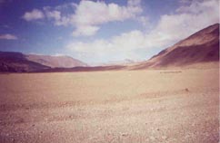
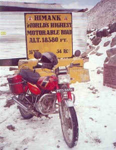
Rohtang Pass (altitude 3978 m) is the first of the four passes that one has to cross to reach Leh. It is about 45 km from Manali and is usually the outer boundary for most Indian tourists who go there to see snow. So far I had been used to the Mumbai-Pune ghat, this one was much more difficult, longer, steeper and narrower, but being on top felt good. Frankly, even at this point I was not sure whether I could make it to Leh because the road was officially closed. The tea stall owner where I had Maggi noodles however told me that over the last few years there is less snow each year and that I should be able to make it. He also told me that a man from Israel had gone on an Enfield just a couple of days earlier. The traffic thinned while climbing down the other side of Rohtang. A Jammu & Kashmir bus heading towards Leh had a puncture, reminding me to ride carefully, and also indicating that the road ahead was not yet closed. After filling the petrol tank completely and taking 10 litres in a Jerry Can at Tandi, just outside Keylong, checked into the HPTDC hotel at Keylong. The caretaker there told me I should not go as the weather ahead was bad. I was now in a dilemma, and at this time decided to break the journey further into 3a - upto Sarchu. Sarchu is beyond Baralacha La (altitude 4800 m) and 107 km from Keylong. It is at a distance such that, should there be a problem I could always come back to Keylong. Beyond Keylong there are hardly any human settlements, there are few army camps and that is about it. The road beyond this point also becomes tough Though it is not as bad as this right through, it climbs above the tree-line at 3500 meters. The Bhaga river now flows in a valley right next to the road. Any mistakes and one would plunge into the icy waters below. The feeling here is different. The traffic is thin, and usually limited to an Army convoy of Stallions or 813s. The overall atmosphere is such that one feels that one is somewhere else. Kind of feels like you are going for a war. The road to Baralacha La was difficult and long. Right from the base of the beginning of the steep climb at Zing Zing Bazaar, an depot with two army/border roads organisation sheds, teeny tiny snow flakes started floating around. Low oxygen results in incomplete combustion and MFG 5456 needed to move into the first gear on some of the inclines. After crossing the origin of the Bhaga river at a Tal one reaches the top of the pass. There was snow at a short distance, but none on the road. The road on the other side was a little better and I reached Sarchu just before 1 p.m. The Army controls the entire road and specifies time for traffic movement. They do not allow one to go beyond Sarchu after 1 pm. I was doubly lucky, at the police outpost they told me that there is some accommodation available at Pang, and the army also let me go through to Pang. To reach Pang one has to climb one more pass, Lachulung La. All these passes are progressively higher. This one is at 5065 meters. There is a steep climb with 21 hair pin bends after which the road starts going down, and I thought we were through with the pass. But, the road once again starts going up and also gets bad and cold. And in the bitter cold, the Border Roads Organisation, which maintains this road, keeps working, paving the path to move goods and people to the borders beyond Leh. Pang was cold. After a lunch of Maggi Noodles for the second day in a row at 4:30 p.m. I had no option but to relax in the tent I had to spend the night in. That was not easy, the altitude made me a little uneasy and later in the evening had nausea and could hardly eat dinner. However some time in the early hours of the morning it all seemed to disappear and I felt quite okay. The next morning, was again very cold, indicating that the weather was beginning to change. All vehicles were having a tough time to start. The truck drivers were burning stuff under the trucks to heat them up. There was one Sumo, which started quite okay and then towed the Armada till it started. MFG 5456 gave no signs of wanting to starting for a while, and, as though it had decided it is time to go, suddenly came alive. A little beyond Pang, the one reaches a plateau called More Plains. This is one of the best parts of the whole journey. You feel as though you are in some other different land - Tibet- that has for centuries been the main link with Ladakh. And, to make it even more authentic there were about 8-10 horsemen in the distance at one point in time! The plateau stretches on for nearly 50 kms after which the climb to Tanglang La begins. This is the most difficult of the four passes and is at an height of 5365 meters. Once you have reached the top, you know for the first time that ab to Leh pahuch jayenge! There is a 30 km long descent to Rumtse, another military camp that also has a canteen, which claims to be the highest Idly-Dosa restaurant in the world. After idly-wada for lunch, it is time to move on to Leh. The road now is relatively easy. Also knowing that you are so close to the civilisation makes things much easier. Soon some settlements appear along the way. They are tiny villages, but, human settlements none-the-less. So the next morning, we were at the District Magistrates Office a few minutes before 10. One of the staff members was very helpful and he explained the entire process and also assisted me through with it. It was 11:15 by the time I got the permit and that meant that we could have a go at Khardung La on the 25th itself!. I was not quite geared for it, so went back to the hotel and put on the usual set of clothing - thermal innerwear, normal clothes, sweater, raincoat, windsheeter, gloves, double socks et al. It was quite sunny when we started off. The road had absolutely no traffic and kept climbing up steadily till South Pullu. After which the road became much more steeper and difficult. By now tough roads were a part of life and were not a cause of concern. The view of the glaciers in the distance was quite literally breath-taking. After a few hours on the road we finally arrived at Khardung La at a height of 5602 meters (18380 feet)! And, one little dream of one little boy came true! This journey has been a GREAT holiday. It has also been a revelation that by enduring on the road with a single minded focus on the goal, ordinary people with ordinary motorcycles can achieve seemingly tough feats, probably, with a little help from providence.
|
|||||||||||||||||||||||||||
Editor: Romola Butalia (c) India Travelogue. All rights reserved. |
|||||||||||||||||||||||||||
 Well, didn't even know where this road was. Though it was not difficult to imagine that it must be somewhere in Himachal Pradesh or Ladakh. ICICI has a reasonably active trekking group, and Shekhar Damle who plays a stellar role in this group has a sackful of books, maps and other information on routes, places, equipment etc. And, I was lucky, he had a couple of guide books on trekking in the Himalayas and Ladakh. The first page that I flicked open landed me where I wanted to go - Khardung La!!! It is somewhere beyond Leh, in Ladakh, on the way to the Siachen Glacier/Nubra valley. The books also talked about the route there. There are only two roads to Leh, one from Srinagar and the other from Manali in Himachal. Given the prevailing conditions in Jammu and Kashmir, the road from Srinagar was out of question. Now, there is a small problem in the road from Manali, it is open only till middle of September, after which snowfall closes the passes one has to go through. It was already end August and there was very little time left.