| Tamil Nadu Geography |
|||||||||
|
About Tamil Nadu • Overview • History • People • Economy • Festivals • Climate
Cities
|
||||||||
The state has an area of 1,30,058 sq. km and a population of over
55 million. Traditionally, the land has been divided into 5
major physiographic divisions - the Kurinji or mountainous
region, the Mullai or forest region, the Palai or arid region,
the Marudham or the fertile plains and the Neidhal or coastal
region.
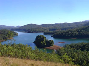
This area receives abundant rainfall and the scenic valleys of Cumbum and Pollachi are tilled with plantations of tea, coffee and spices. Yercaud in the Shevaroy hills is famous for its fruit orchards and banana and coffee plantations. The perennial river of the state is the Cauveri, which originates in Coorg in the neighbouring state of Karnataka. The Cauveri and its delta in Thanjavur irrigate the fertile Coromandel plains. Nagapattinam region is known as the granary of Tamil Nadu. The other rivers in the state are the Palar, Ponnaiyar, Pennar, Vaigai and Tamiraparani all of which flow eastward from the inland hills. The Cauveri and its tributaries are Tamil Nadu's most important sources of water and power.  Apart from the rich alluvial soil of the river deltas, the predominant soils are clay, loam and red laterite (soils with a high content of iron oxides and aluminum hydroxide). The black cotton-growing soil known as regur is found in parts of Salem and Coimbatore in the west, Ramanathapuram and Tirunelveli in the south, and Tiruchchirappalli in the central region of Tamil Nadu.
Tamil Nadu's wildlife sanctuaries like Mudumalai and Annamalai (Indira Gandhi wild life sanctuary) are situated in the hills of the Western Ghats and are the habitat of elephants, tigers, bisons and a variety of monkey and deer.
|
|||||||||
Editor: Romola Butalia (c) India Travelogue. All rights reserved. |
|||||||||
 Tamil Nadu is bounded by Karnataka and Andhra Pradesh in the
north and Kerala in the west. The waters of the Bay of Bengal
and the Indian Ocean wash the coastal eastern and southern
boundaries respectively. Point Calimere and Mudumalai wildlife
sanctuaries define the eastern and western tips of the state
while at the northern extreme is Pulicat Lake and at the
southernmost tip is Cape Camorin or Kanniyakumari.
Tamil Nadu is bounded by Karnataka and Andhra Pradesh in the
north and Kerala in the west. The waters of the Bay of Bengal
and the Indian Ocean wash the coastal eastern and southern
boundaries respectively. Point Calimere and Mudumalai wildlife
sanctuaries define the eastern and western tips of the state
while at the northern extreme is Pulicat Lake and at the
southernmost tip is Cape Camorin or Kanniyakumari.
 Coastal Tamil Nadu comprises the Coromandel Coast in the north
and the Fisheries coast in the south. Mylapore, Poompuhar and
Mamallapuram were the famous ancient ports on the Coromandel
from where merchant ships sailed to Rome, Greece and the Far
East. Once famous for its pearls, the Fisheries coast is a
major tourist attraction since it has some of the most
important pilgrim centres in India. There are mangrove forests
at Pichavaram and prominent bird sanctuaries at Pulicat Lake
and Vedanthangal, though the latter is not on the coast
itself. The arid land in the state is confined to a small area
in Tirunelveli district and is known as the Palai.
Coastal Tamil Nadu comprises the Coromandel Coast in the north
and the Fisheries coast in the south. Mylapore, Poompuhar and
Mamallapuram were the famous ancient ports on the Coromandel
from where merchant ships sailed to Rome, Greece and the Far
East. Once famous for its pearls, the Fisheries coast is a
major tourist attraction since it has some of the most
important pilgrim centres in India. There are mangrove forests
at Pichavaram and prominent bird sanctuaries at Pulicat Lake
and Vedanthangal, though the latter is not on the coast
itself. The arid land in the state is confined to a small area
in Tirunelveli district and is known as the Palai.
 The mixed deciduous forests of the region have over 3000 plant
species. One of the most noteworthy flowers is the Kurinji of
Kodaikanal, which blooms once in 12 years. Cinchona from which
quinine - a drug for treating malaria - is extracted and
eucalyptus grow abundantly in the Nilgiris. Forests of
medicinal herbs are found in Palani hills and Courtallam.
Products of Palmyrah trees are used as raw materials for
several cottage industries. Rubber is the main plantation crop
in Kanniyakumari and the more exotic sandalwood grows, though
not in very large numbers, in the Javadhu hills of Vellore
district.
The mixed deciduous forests of the region have over 3000 plant
species. One of the most noteworthy flowers is the Kurinji of
Kodaikanal, which blooms once in 12 years. Cinchona from which
quinine - a drug for treating malaria - is extracted and
eucalyptus grow abundantly in the Nilgiris. Forests of
medicinal herbs are found in Palani hills and Courtallam.
Products of Palmyrah trees are used as raw materials for
several cottage industries. Rubber is the main plantation crop
in Kanniyakumari and the more exotic sandalwood grows, though
not in very large numbers, in the Javadhu hills of Vellore
district.