| Destinations
|
||
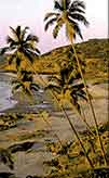 Goa's coastline with palm lined, golden sandy beaches coupled with its unique and carefree lifestyle, warm sunshine and friendly people have made it a tourist destination for people from around the globe.
Goa lies approximately 400 km south of Mumbai. The western Indian state is bounded by Sindhudurg district of Maharashtra in the North, by Belgaum in the East, by Karwar district of Karnataka in the South and by the Arabian Sea in the west. Being locked by land, sea and mountains, Goa has a mild temperature, which ranges from 21�C in winter to 35� C in summer with the monsoons prevailing from June to September. Goa includes a portion of the Western Ghats. The highest mountain is Sonsogor (3,827 feet) in the Sahyadri range. It's rivers -Tiracol, Chapora, Mandovi, Zuari, Sal and Talpona have their origin in the Sahyadri ranges and flow westward into the Arabian Sea. The mouths of the two largest rivers Mandavi (38.5 miles) and Zuari (39 miles) envelop the triangular island of Goa (Ilhas), the apex, called the cape, being a rocky headland separating the harbour of Goa into two anchorages. The rivers break the 65 mile long coastline to reach the estuaries and bays which mark off idyllic palm-fringed beaches like Arambol, Vagator, Anjuna, Baga and Calangute in the North and Colva, Cavelosim, Betul and Palolem in the South. |
More on Goa • Overview • History • Economy • Festivals • Wildlife • Towns • Getting Around • Climate • North Goa Beaches • South Goa Beaches Impressions • An Introduction • Barracuda |
|
Goa is divided into 11-talukas and was a 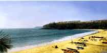 Union Territory for 26 years before gaining full-fledged statehood on August 12th 1987. Built on the left bank of the Mandavi estuary, Panaji is Goa's capital and the seat of government. Also known as Panjim and Nova Goa in the local dialect, it was originally a suburb of Old Goa. A modern port, it contains the archbishop's palace, the government house, teachers' training college and several secondary and primary schools. Goa University is located at Bambolim, near Panaji. Old Goa is, for the most part, a city of ruins. Marmagao, Goa's largest town, is sheltered by a promontory and outfitted with a modern breakwater and quay. The best port between Mumbai and Calicut (Kozhikode), Marmagao is Goa's main port through which iron ore is exported. Union Territory for 26 years before gaining full-fledged statehood on August 12th 1987. Built on the left bank of the Mandavi estuary, Panaji is Goa's capital and the seat of government. Also known as Panjim and Nova Goa in the local dialect, it was originally a suburb of Old Goa. A modern port, it contains the archbishop's palace, the government house, teachers' training college and several secondary and primary schools. Goa University is located at Bambolim, near Panaji. Old Goa is, for the most part, a city of ruins. Marmagao, Goa's largest town, is sheltered by a promontory and outfitted with a modern breakwater and quay. The best port between Mumbai and Calicut (Kozhikode), Marmagao is Goa's main port through which iron ore is exported.

|
||
Editor: Romola Butalia (c) India Travelogue. All rights reserved. |
||