| Trekking
Trekkers and Plain Fear |
|||||||||||||||||||||
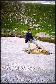
It was my sheer fear of the civilised terror of Lutyen's Delhi that drove me across the Rohtang Pass in the Pir Panjal range through the green and treeless wonder of the high altitude desolateness of Lahaul and into the barren moonscapes of enigmatic Spiti. At around 14,500 feet, satiated by the psychological distance from New Delhi, I reached the Chandratal Lake, aptly named, as it is in fact, moon shaped. For theorists who proclaim that in trekking, unlike other kinds of travel, the journey is itself a destination, Chandratal has a beautifully blatant way of disagreeing. In a sly way, this heavenly place makes it clear what a high point of a trek really means. I have returned to Lutyen's Delhi and even while I drive through the polluted fumes of development, my eyes momentarily close and play back the memory of a path on the green bank of a turbulent river, across the wonder of more than twenty glaciers, myriad clouds that block the trail with an ephemeral quality all their own ...and then a mirrored sheen of peace, with more than twenty snow clad soldiers protectively encircling the magic called Chandratal. July 19, 1998: Rohtang Pass ( 13, 500 ft ) really previewed to me what was coming. It was the month of July in the year '98 and yet mist wrapped snowfields and glaciers completely covered the expansive pass. |
More About Himachal • An Overview
Trekking
Travelogues
Impressions
Adventure activities | ||||||||||||||||||||
It was in fact something to do with the snowfall of the season which fell last on 10th of June to a height of 10 to 15 feet at Rohtang in the Pir Panjal range in Himachal Pradesh and in Lahaul and Spiti, valleys of the Great Himalayan range in the same state. A number of skiers benefited form the extended snowfall and Rohtang was consequently crowded with a brazen touristy claim. The mode of journey : A local Bus from Manali to Gramphoo across the Rohtang Pass.
Still, we started trekking immediately after getting off the bus, towards Chatru. And pretty soon we found ourselves jumping from rock to rock to avoid the hundreds of waterfalls falling directly on our heads. Frequently we took our boots off and quickly crossed freezing glacier waters. Right through, we had the company of the roaring Chandra river, cutting across the green mountains covered in several places by large and small glaciers.
Occasional white peaks dotted the landscape letting their glaciers tumble into the river, sometimes forming pretty little snow bridges in the narrower sections. A lot of greenery all around but completely treeless. It did not get dark till eight in the night after which it was a well-deserved sleep. Through the night it rained with a consistent patter on the tent. It was pretty cold but the tent was cozy. The weather in the Himalayas has started changing. Earlier, one would expect no rain at all beyond Rohtang. 5.00 a.m., July 20th: We were up at around 5.00 a.m. A clear sky. The high peaks were glowing brilliantly, with clouds wrapped around in hues of orange. The valley was still cold with the sun not quite having reached it. A filling breakfast of maggie noodles and a cup of tea and we are ready to walk again. This time we take a small short cut climbing a steep green mountainside studded with yellow coloured alpine flowers. And suddenly a large glacier blocks the trail. It's a cautious crossing across, only to arrive at a few more glaciers and a few simple, though cold river crossings. The greenery A lot of the greenery is now replaced by sharper gradients and the valley has become narrow. Plenty of huge and high glaciers, with a few treacherous crevices. And of- course, the ever-present Chandra, fed by glacier water from the mountainsides. A tiring section and the last thing we could we afford was an accident. Suddenly, a glacier gives way and Rashmi, my wife and trekking companion, plunges 4 feet into the freezing water. Fortunately, she doesn't slip down the mountainside. But, nevertheless, her knees are both jammed and excruciating pain accompanies her during the walk to Chota Dara.
6.30 a.m., July 21st: The camera sees considerable action with close views of glowing peaks, splendid with the cloud cover. The backpacks are soon strapped and yesterday's tired legs ready to move again. I t's a very rocky and barren moonscape, interrupted by the occasional glacier. A lot of river crossings and then finally a massive glacier threateningly waits in welcome. It's a precarious and a very long and slippery walk on the glacier with some delicate balancing. Suddenly an awesome sight greets us on the riverbank. Coming straight down to the river is the fortified massif of the Bara Shigri glacier, white in some places and grey with age in others.
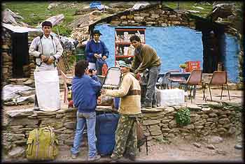
4.00 p.m., July 21st: With it's wind swept and rocky landscape, Batal is true to the bizarre moonscape of Spiti. Aptly called Pagal Nala ( the mad river! ), it marks the entry to Batal. This one is a complicated river crossing, but after much debate we finally cross it, holding hands. Many a successful mountaineering expedition has met its match with tragic results at Pagal Nala. At least two of these accounts are documented on stone at Batal. Both were successful expeditions to the Lalana peak in the vicinity. One was, in fact, in the 70s, an all women Indian expedition atop the virgin Lalana.
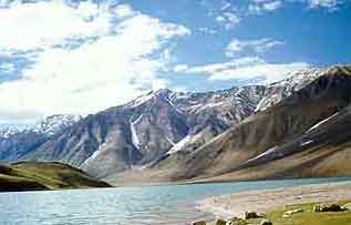
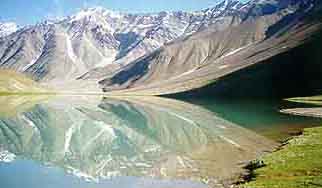
Actually, Batal is geographically a kind of funnel for the wind that screams through the KunZum La Pass. And at nearly 15,000 feet, turbulent and fluctuating air pressures determine this unique phenomena. Dinner at Batal. No prizes for guessing the menu ! Sleep is not quite peaceful, with wild dogs constantly active at the campsite. 7.00 a.m., July 22nd: An air of anticipation and excitement. Today we finally trek to Chandratal Lake. We quickly get cracking and soon cross the precarious rope bridge to enter Spiti. A small temple is situated at the end of the bridge. It is rumoured that accidents on the bridge have practically stopped after the presiding deity was constructed. Across the bridge is yet another world all together. Sharp mountainsides with grey stones hanging loosely mark the steep ascent. Out of the blue we sometimes come across verdant meadows carpeted with alpine flowers. And then its back to the barrenness. With the river far below, the trail is confusing and quite unclear. It is an endless walk that takes its toll on the legs. Finally a series of meadows appear. Each time one meadow appears, one expects the Chandratal in the subsequent glacial bowl. But for a long time the lake remains elusive. I finally clamour up a mountainside and discover a beautiful moon shaped lake with white peaks closely around it. It looks like many of the photographs of Chandratal that I've seen. But somehow the lake seems much smaller. I send off a porter to explore around and he finally locates the real Chandratal. We accompany him and enter a beautiful meadow with a joyous stream coming out of a huge moon shaped lake. Over 20 peaks crown it on all sides, reflecting magically and creating that fabled upside-down world of Chandratal which so many trekkers dream of. The feet are no longer tired. Delhi is totally forgotten, a pretty campsite is set up, a ravenous appetite is catered to and the camera is clicking roll after roll. The intoxicating feeling of exhilaration sets in and takes us into another world. I recall the words of a close trekking partner whom I lost during a trek in Sikkim. "Why is it that the more remote and inaccessible a place is, the greater its magic ?" We begin, the next day, a journey back to Gramphoo and over the Rohtang Pass and into Manali. The same route, but I could describe it again, for no matter how many times you walk that trail, each time it seems new. But next time, another trek, on another route, in the same old timeless drama of the Himalayas.
|
|||||||||||||||||||||
Editor: Romola Butalia (c) India Travelogue. All rights reserved. |
|||||||||||||||||||||
 4.00 pm July 19, 1998: With a vehicle overturning on the precipitous road near Rohtang Pass, the tourist traffic which visits Rohtang was jammed with blaring horns. Yet, all of it was more than compensated by the bright dark green mountainsides at the height of the rainy season. A number of glaciers stood in greeting, notable among which was the Beas glacier, which,according to one theory, is the source of the Beas river. Finally we arrived at Gramphoo, Lahaul across the Rohtang Pass. Gramphoo is on the road from Rohtang to Keylong, which goes further to Leh in Jammu & Kashmir. Gramphoo is not more than a couple of dhabas (tea shacks). This is where we got off the bus. Ideally, we should have reached at 12.00 noon, which would have enabled us to trek and reach Chatru i.e. Camp 1, by evening.
 retains its billiance for a good part, till the trail winds into a section with gigantic boulders strewn over the valley. Then it's a tiring haul over the boulders, across glaciers and through freezing water. Merely to Chatru would be too small a walk for a single day and continuing to Chota Dara beyond Chatru would be a long haul. We decided on the latter. So that made it a 25 kms stretch with a more or less continuous though gradual ascent. We arrived at Chatru at 2.00 p.m., slowed considerably by many river and glacier crossings. It's lunch at Chatru. A plateful of rice and dal, followed by a cup of the refreshing brew. A few swigs of glucose from the water bottle and off we are towards Chota Dara., which is about 16 kms away.
 It gets dark after 8.30 p.m. and clouds move in, in frightening proportions. A lonesome whistle of the wind can be heard in the room and the rough and rocky terrain forbiddingly stares in through the largish window. We are looking forward to the next morning as we fall asleep. A major relief is, taking the boots off tired feet. Blankets never felt cozier and sleep more inviting.
 We set up camp at Batal. The site is behind an outcrop that separates it from the three dhabas of Batal. A very rocky campsite with loose flat grey stones, hanging on to the mountainside. Many peaks frame the bizarre landscape. Strangely, every evening, a very strong wind blows and almost rips the tents apart. At around 10.00 p.m. it is absolutely still as if nothing at all had happened ! Tenzen, a friend of mine, a local of the place puts it down to the 'style' of Batal!