| Trekking Sandakphu Phalut Singalila Ridge Trek |
|||||
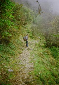
We trekked 85 km in four days to cross the Singalila Range in the last week of February 2004. Having been to Sandakphu earlier, we were looking for a greater challenge. There were six of us, out of whom three had some trekking experience.
|
More on W Bengal • An Overview
Trekking
Travelogues
Adventure activities | ||||
 The trek started from Manebhanjang (2100 m), the conventional starting point for Sandakphu. We booked a commander jeep from Siliguri to reach Manebhanjang at 4 pm, and quickly took shelter in one of the cheap lodges there before starting the hunt for a good guide. Most of them were not comfortable with the path to Sikim through the Singalila pass. Eventually we got an experienced 51 year old who wanted 5 days wage for the strenuous 4 day trek. He told us that the path ahead of Sandakphu was dangerous owing to remaining snow from the previous winter and we might not even be able to cross the pass at that time of year.
We had tea at Meghma and marched towards our lunch halt, Tumling, with its three huts and great deal of hospitality from the hostess. Here we met a British man and a couple from Sweden who were going for Sandakphu and decided to stay there for the day. At Tumling the sun created a play of light and shadow, visible across the meadows that extend to the vast horizons in the interlocking spars of this great mountain range.
Next morning we had to move down to Gairibas (2800 m), a check post on the Nepal India border. After that was the sheer uphill climb to Kayakata, where we reached at 10 am, had tea and headed towards Kalpokhari. The team divided as the path did, one went around the cliff and another over it. The view from the top of the cliff was rewarding, even if the climb was arduous.
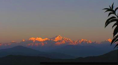
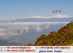
The next day began with glorious views of Kanchendzonga with the first rays of sun adorning it. With a 170-degree breath-taking view of Nepal and Sikkim Himalayas, one can see Mt Everest (highest), Mt Kanchendzonga (3rd highest), Mt Makalu (4th highest), Mt Lhotse (5th highest), Pandim, Kumbhkarn, Kabru, Dome, Machchapuchare from Sandakphu. The Kanchendzonga, Kumbhkarn and Pandim range together are referred to as "sleeping Shiva" or "sleeping Buddha".
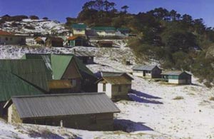
At noon after lunch we had to cross a cliff to reach e deserted village, Sabargram. While ascending from the cliff, I slipped on a long strip of ice and fell 20ft . Fortunately there was no bolder or rock and I only sustained minor injuries. It was around 2 pm and we still had to trek 10 km before dark, so there was no time to nurse my wounds and fallen pride. The next 6-7 km was more or less even, with the last 3 km of incline to be negotiated in foggy weather with a visibility of 2-3 meters. Wind at very high speed made it extremely difficult to ascend, but without a choice, we braved on towards the safety of a trekkers' hut. It was a relief to reach the snow covered stone-paved hut. The snow had to be melted on a wood fire for drinking, which left a typical aftertaste of burning wood.
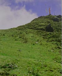
Next morning at Phalut we saw the wreckage of the older trekkers' hut that had got devastated in 1960's. It was so windy here, it was difficult to keep our balance as we moved along the ridge. There was no path or even footprints, only patches of virgin snow everywhere. People debate whether the view from Sandakphu is better, or from Phalut. The peaks are much closer from Phalut, but the majesty of the panorama is experienced at Sandakphu.
As on the previous day we carried our lunch stopping to have it halfway between Singalila pass and Chiyabhanjang, where there is an army camp. This placce was being used as a temporary resting place for locals who move with their yaks. The next 4 km upto Chiyabhanjang were fantastic, with wide paths and colourful trees. Snow patches on the road became rare and seemed less dangerous.
The journey to Siliguri was by truck, thanks to a ruling political party meeting which led to withdrawal of most public vehicles from the roads of Sikkim. But that's another story...
|
|||||
Editor: Romola Butalia (c) India Travelogue. All rights reserved. |
|||||
 Singalila range is the main mountain range in West Bengal. It runs through the border of India and Nepal and merges into the southern ridge of Kanchendzonga range. Phalut (3600 m) is a peak at the border of Nepal, Sikkim and West Bengal and is a little lower than Sandakphu (3636 m), the highest peak of West Bengal. To enter Sikkim one has to cross the Singalila Pass (3700 m), to which there is an adjoining peak, the Singalila Peak.
 The next morning, we had tea and started by 7 am - our destination was Chitrey, 4 km steep uphill. The path was wide and paved with stone, but the inclination was 30 degrees all through. At Chitrey, we had breakfast of noodles and tea. Then we had to hit the road for Meghma. As indicated by the name, (megh means cloud), we were trapped by a thick layer of cloud and fog soon. The path was still uphill and one of us already had a cramp in his leg.
 After lunch of khichri at Tumling, we proceeded towards our night halt at Joubari, a village in Nepal. There are many places in the Himalayas with strong breeze, but at Joubari the locals have to make cordons of bamboo slices along the northwest slope of the village to protect themselves from being blown away. At a height near 3000 m, this village has an adjacent peak, the Joubari top from where the sunrise is spectacular. The night was colourful with Chhang (Tibetan beer), hot food and a good sleep. The total distance covered on the first day was 15 km.

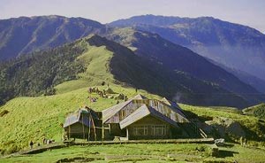
 At Kalpokhari, we had lunch and then took a shortcut to Bikebhanjang, the last stop before Sandakphu. It was a good trai. A local dog accompanied us, as is a common occurrence in this part of the Himalayas. Bikebhanjang has a hut, with a shop window and an informal lodge for trekkers. At this time, there was no one here. We took a brief rest and negotiated the toughest trail so far. The last 4 km from Bikebhanjang is a continuous climb of 30-40 degree. We reached Sandakphu around 3:00 pm to enjoy a clear evening and a majestic sunset.
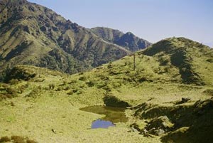
 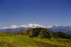 Bone-tired, we started towards Phalut on the third day of our trek at 7:30 am. Beyond Sandakphu, the 23 km trail has no place to halt for refreshment, and the number of trekkers dwindle drastically. Trekkers have to carry their lunch and water. We were lucky to have a guide who knew of a spring midway. The path is beautiful, gentle slopes uphill and down, with the ever-present Kanchendzonga. There is a meadow named Chandra Valley 4-5 km from Sandakphu, with a small muddy lake, supposedly born of a forest fire some 30 years ago. The skeletons of trees, dead and burnt black have an eerie appearance.
 The night was really cold with bitter winds. We shared a dormitory with 5 Indian Army Jawans who were stationed there for 6 months. Exhausted, we slept after a badly cooked meal.
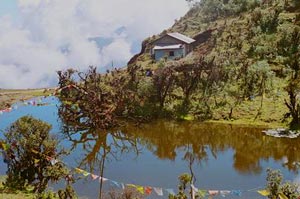
 As we climbed down, we came across a lake at Toyephulebhanjang. Two of our members were feeling distinctly unwell. As we marched on and the path became tougher, they grew weaker and slower. After climbing a steep gradient uphill, for about 1000 m, quite abruptly, we came to the Singalila pass (3700 m) at about 12:30 pm The weather was frightening, with indication of rain and hail storm. Visibility was two meters at most. We quickly climbed down the slippery snow covered narrow path towards Sikkim.
 We reached Chiyabhanjang at 3 pm and left after a border security check. The path was a steep and damp descent to the river Great Rangit. The 2 km descent was endless. Everyone was worse for wear with twisted ankles, and aching bones. Even our trusted and experienced guide fell. Thereafter we walked along the riverbed on a 6 km trail that seemed like it was forever. We reached Uttare at 6 pm, dead tired. This was our last night halt in the hills. From here we hoped to get a car to Siliguri via Jorthang.