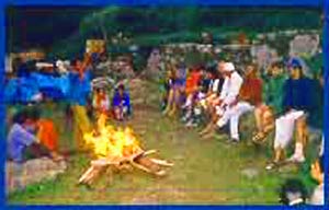
| Before leaving the camp all the yatris would assemble together to start the days trek with chants of "Om Namah Shiva". |
| | |
|
Just about 100 ft from us was the Maruti van, it's front bumper inches away from the huge mass of rock and earth that had come crushing down the road in a landslide barely missing the Maruti. The occupants of the van were completely shaken. I realised this was no ordinary trek.
|
 It had all started in April 1996, when I decided to apply to the Ministry Of External Affairs to participate in the Kailash Manasarovar Yatra (Details are notified each year through the Press, TV, Radio advertisements in the month of March). It was July and I had just about given up hopes of being selected, and was contemplating the possibility of another trek to liquidate my savings when the Telegram from the Ministry informed me of my selection in the 9th Batch. The telegram stated that the journey would commence on 29th July and I would have to appear for briefings/medical on 24th. The information booklet sent by the ministry contained all the relevant information. The sections covering clothing and medicines were particularly helpful in packing the right things in the right quantities.
 The actual trek was supposed to start from Tawaghat, about 19 Kms from Dharchula. Another landslide barely 2 Kms from Dharchula ensured that 17 Kms were added to our trek. From Tawaghat the trek of 9 Kms to Pangu (7,260ft) was very steep. Locals call it Thanedar- Ki- Charhai. (Cop's Climb) The path winds up the sides of a cliff with no tree cover, and no source of drinking water. The next day's trek to Sirkha was gentler and the group took the longer but more comfortable route via Narayan Ashram - a beautiful Ashram at 9,900ft. The Ashram is now headed by a Mataji, after the death of it's founder Shri Narayan Swami
|
By the time the group reached Sirkha, there was already a bonding between the yatris. For some it was the commonality of a shared pilgrimage, for others it was the discipline of a trek. We had to get up as early as 4:00 a.m. for tea. With departures at 5:30 a.m. there was little time for anything else other than packing/toilet/breakfast.
|
| At Navidang, the famous 'Om' Parvat can be seen on a clear day. Snow fall on the natural curves in the black rock face carve the symbol!
|
| | |
|

 Before leaving the camp all the yatris would assemble together to start the days trek with chants of "Om Namah Shiva". Evenings were spent in bhajan recitals and discussions about the following days trek.
From Sirkha the route took us to camps like Gala, Malpa and Budhi. The path was mostly alongside the 'Kalinadi' river, which also acts as the international boundary between India and Nepal. The route between Gala and Malpa is particularly spectacular. Here the yatris get their first glimpse of the Kalinadi after leaving Dharchula. The path starts with an even stretch of about 1.5 Kms followed by a sharp descent of about 3 Kms. People who had hired horses had to walk this length. This stretch is particularly risky because the path here is treacherously narrow. After the descent the path comes very close to Kalinadi with it's thunderous roar drowning all other sounds. Here the trek is easy and flat. The path is curved out of the rock face and we had to watch out for sharp overhangs and small waterfalls falling right on the path.
Before leaving the camp all the yatris would assemble together to start the days trek with chants of "Om Namah Shiva". Evenings were spent in bhajan recitals and discussions about the following days trek.
From Sirkha the route took us to camps like Gala, Malpa and Budhi. The path was mostly alongside the 'Kalinadi' river, which also acts as the international boundary between India and Nepal. The route between Gala and Malpa is particularly spectacular. Here the yatris get their first glimpse of the Kalinadi after leaving Dharchula. The path starts with an even stretch of about 1.5 Kms followed by a sharp descent of about 3 Kms. People who had hired horses had to walk this length. This stretch is particularly risky because the path here is treacherously narrow. After the descent the path comes very close to Kalinadi with it's thunderous roar drowning all other sounds. Here the trek is easy and flat. The path is curved out of the rock face and we had to watch out for sharp overhangs and small waterfalls falling right on the path.
| Quite suddenly we found ourselves in China. The experience of crossing the overland border of India was new to most of us, and had quite an emotional impact.
|
| | |
|
Gunji is the first camp on the Indian side which is situated at over 10,000ft. The yatris are given a final medical examination before they are allowed to proceed further. From Gunji, the last Indian village en route, U.P. police relinquish charge of the group to the Indo Tibetan Border Police (ITBP) personnel.
|
Beyond Gunji, the trek is comparatively easy and flat to Kalapani (11,880ft) and finally to the last camp, Navidang (13,880ft). At Navidang, the famous 'Om' Parvat can be seen on a clear day. Snow fall on the natural curves in the black rock face carve the symbol!
 From Navidang the famous Lipulekh pass is just 7 Kms. We were woken up at 2:30 a.m. to prepare for the steep climb that would take us from 14,000ft to 17,000ft. At 3:30 a.m., braving the freezing cold and light drizzle, torches in hand, we marched silently on. The laboured breathing of the horses and the clatter of their hooves on the stones was the only sound of life in the procession. Faces could not be distinguished and the sight of the moving torches against the blackness of the night was too bizarre for some, and they made an attempt at conversation. The strain of trekking at that altitude however prevented it, and we lumbered on our way up in a surreal dream.
Slowly, the first traces of the dawn to follow, lit silhouettes of people and horses. The outlines of the mountain peaks against the crimson sky made us realise that we were close to the top of that particular range. Exhausted, progress was in slow laboured steps
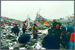
Finally, ITBP personnel told us that we were at the Lipulekh pass. From where we stood shivering in the cold, the straight 100 metre path turned sharply to lead to a gap in the mountain wall, and China beyond. 15 minutes later we crossed paths with returning yatris in an exchange of charge. Many of us handed letters for posting home, before moving on.
Quite suddenly we found ourselves in China. The experience of crossing the overland border of India was new to most of us, and had quite an emotional impact. People looked back at what seemed familiar, what was home. The landscape is the same, the rock faces are not different, and yet there was this awareness of the intangible border. 100 meters behind is the soil of my own country and now I am walking through a foreign land!
|
| A little below Dolma pass, we saw Gouri Kunda, believed to be the exclusive bathing place of Mata Parvati. The emerald green water of the lake amidst the pristine surroundings was a visual delight.
|
| | |
|
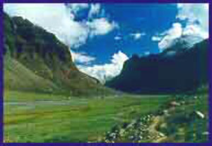
The stark, barren beauty of the Tibetan plateau lay before us. There is no vegetation to be seen, but the various colours of the stone compensate it. The undulating landscape is ochre. Instead of rocks, there were small granular stones. The sunlight created unique patterns of light and shade on the vastness ahead.
 Taklakot, the first Chinese town was a 2 hour bumpy bus ride away, over un-metalled roads. Two days in Taklakot gave us the taste of forgotten civilisation. Taklakot has restaurants, shops, and post offices from where one can call India at the whopping rate of $7 per minute.
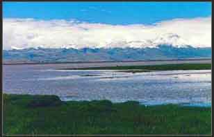
On 10th August, we left Taklakot by bus for the Kailash and Manasarovar parikramas. Due to lack of accommodation in the camps on the parikrama routes, our batch was divided into two smaller groups of 15 each. My group was scheduled for the Manasarovar parikrama first. Manasarovar lay on one side and Raksastal on the other. About an hour out of Taklakot we caught our first glimpse of Raksastal. With it's large expanse of tranquil, turquoise water, Raksastal bore no resemblance to it's mythological images of dark and evil. On a clear day the reflection of Mount Kailash can be seen on the waters of Raksastal.
| I was overwhelmed by my own awareness of the insignificance of human beings in the vastness of the universe.
|
| | |
|
A little distance ahead was camp Zaidi on the banks of Manasarovar. Alighting from the bus we walked the few meters to the shores of Manasarovar. There was total silence. Everyone had their own reasons, their own dreams for undertaking this yatra. This was the moment of fulfilment.
|
 I was overwhelmed by my own awareness of the insignificance of human beings in the vastness of the universe. The waters of the Manasarovar, mantled by an overcast sky, were not blue but had an ethereal quality in it's milky white appearance. The water was relatively calm, although we were told that big waves appeared later, as the wind picked up with the progressing day. No one thought of a 'dip' - it was too cold for that.
Leaving Zaidi we reached Hore around 2 p.m. Hore is a small habitation on the northern banks of the Manasarovar. Our parikrama of Manasarovar was to begin here:
Hore to Chuggu on the first day, Chuggu to Zaidi on the second and one day was for rest, puja and a holy dip at Zaidi. Nature however had other plans for us.
About 3 kms from Hore we came across a river. A small stream, with just about knee deep water for the greater part of the year, was now a gushing river in spate due to the heavy rains of the past few days. All attempts to cross the river proved futile. Our team leader, a young Indian Foreign Service officer from Delhi walked up the river bank for about a kilometre to find a suitable place to cross. He returned grim faced, an hour later. With extreme reluctance, we had to abandon the Manasarovar parikrama. We were stranded in Hore for the next four days. On 14th August, the river subsided and a Chinese Govt truck came to take us to Tarchen for the Kailash parikrama.
 Tarchen is a small town on the southern side of Mount Kailash. On the morn of Independence day, we commemmorated the day by singing the national anthem. Packing dry foods, we started the 23 Kms trek to Dhirapuk. This route is over flat ground, passing through some of the most fascinating terrain.
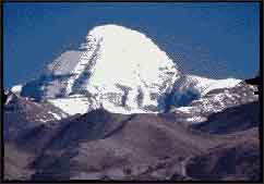
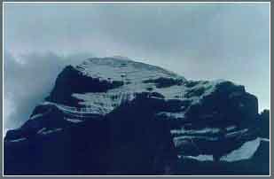
With Mount Kailash on the right side one can see the various faces of the holy mountain as one proceeds on. The southern, western and northern faces of Kailash are so varied in appearance that it is difficult to believe that they are different faces of the same mountain.
The trek also offers a chance to see the holy mountain at very close proximity. The giant black rock is in total contrast to the surroundings. The whole area is dominated by stones and rocks of a dusty grey colour, in the midst of which stands Kailash, capped in ice. The sight is awe-inspiring and a reminder of why this mountain has been worshipped for centuries by people from four religious faiths
 From Dhirapuk one gets the best view of Kailash with it's black stone rising 5,000 ft in a monolithic vertical rock face. From here, we started the next days trek to Zong Zerebu, 27 Kms away. On the way, we crossed the famous Dolma pass at 19,500 ft. There was a slight drizzle, and the 6 Kms trek to Dolma pass was back-breaking. The strain of the climb in the steady drizzle took its toll and everyone was too enervated to do much else than rest a while before starting the downhill journey to Zong Zerebu.
A little below Dolma pass, we saw Gouri Kunda, believed to be the exclusive bathing place of 'Mata Parvati'. 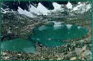 The emerald green water of the lake amidst the pristine surroundings was a visual delight. The lake, at 18,400ft, is one of the highest in the world. From Dolma pass to the valley below is a steady descent of about 3 Kms, followed by a flat trek of about 18 Kms to Zong Zerebu. We reached Zong Zerebu as dusk settled. All the yatris were exhausted. Some had to face a snowstorm while they were at Dolma pass. The experience of a snowstorm at 19,500ft is impossible to describe.
Zong Zerebu to Tarchen was an easy trek of 12 Kms. Back at Tarchen, the fact that we had completed the parikrama was uppermost in our minds. The next day on the bus for Taklakot, we stopped en route at Zaidi for the much-awaited dip at Manasarovar.
On 20th August,we started our long return journey from Taklakot. The Kailash-Mansarovar Yatra was over. The memories of it remain permanently etched in my heart and mind.
Photo Credit: Sumanta RoyChowdhry
 Our group of 30 people left Delhi in the early hours of 29th July1996, spending the first night in Kumaon Mandal Vikas Nigam's (KMVN) tourist bungalow at Almora. 30th July was a clear morning when we set off from Almora to Dharchula in a bus and an accompanying red Maruti van. On the downhill journey to Dharchula, situated at only 2,970ft, the Maruti van was ahead of us carrying four people including a newly married couple on their first journey together.