| Destinations
|
|||
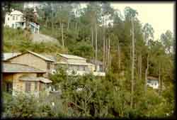
The newly formed state of Uttarakhand is immediately recognisable because it is home to 4 of the most revered pilgrimage spots of Gangotri, Yamunotri, Kedarnath and Badrinath. Uttarakhand became the 27th state of the Republic of India on the 9th of November 2000. The State is carved out of Uttar Pradesh. It occupies 17.3% of India's total land area with 51,125 sq. km. It has a population of about 6.0 million at 94.4 per sq. km. It shares borders with Tibet and Nepal and with the Indian state of Himachal Pradesh, and has 13 Districts, split administratively into Garhwal and Kumaon divisions.
With great views of the Himalayas, apart from the well known pilgrimages and hill stations, it offers wonderful travel destinations to lesser known places and offers much in adventure activities, like skiing, yachting, trekking and mountaineering.
Water sports such as rafting can be tried out on the Yamuna, Alaknanda, Bhagirathi, Bhilangana, Mandakini and the Mahakali. There is a sailing club at Nainital. The state offers excellent trekking terrain and some of the famous treks take you to the Valley of Flowers and Pindari, Sunderdhunga and Kafni glaciers. The Government of India has awarded the National Tourism Award in the Category of Special Award for Efforts in the Development and Promotion of Tourism to the State Government of Uttarakhand, in 2002. Focused, planned and time bound development of trek routes, yatra routes and adventure sports such as river rafting, paragliding, skiing, mountaineering are planned by the state. The State Government is adopting the master plan approach for development of wayside amenities, new tourist destinations, development of Tehri Dam area as a tourist spot etc. Special emphasis is being accorded to promote cultural tourism and wildlife in the State. |
More on Uttarakhand • Corbett National Park • Valley of Flowers • Nainital • Almora • Mussoorie • Kausani • Char Dham • Badrinath • Haridwar • Rishikesh • Festivals of Kumaon Uttarakhand Districts • Pauri-Garhwal • Tehri-Garhwal • Dehradun • Uttarkashi • Chamoli • Rudraprayag • Haridwar • Almora • Bageshwar • Champawat • Pithoragarh • Udham Singh Nagar • Nainital • Char Dham Yatra
Travelogues
WildLife
Pilgrimages
Trekking |
||
The administrative districts and the principal towns in each district are:
Dehradun The nearest airport is Jolly Grant, 24 kms from Dehradun. It is connected among other places, to Amritsar, Howrah, Bombay, Delhi, Lucknow, Varanasi and other major cities. Dehradun is well connected to other parts of India with a wide network of road routes.
Pauri-Garhwal The nearest airport is Jollygrant (155 kms.) via Srinagar and Rishikesh. The nearest railway station is Kotdwar (108 kms.). Pauri is well connected by road to Dehradun, Rishikesh, Kotdwar and other cities of the Garhwal and Kumaon.  Tehri-Garhwal:
The nearest airport is Jollygrant at 101kms. Rishikesh is the nearest railway station. Tehri is well connected by road to Dehradun, Mussoorie, Haridwar, Pauri, Rishikesh, Uttarkashi and other parts of the region. Uttarkashi Nearest airport is Jollygrant, 162 kms. Nearest railway station is Rishikesh, 145 kms. Uttarkashi is well connected by motorable road to Dehradun, Rishikesh, Haridwar and other major towns of the state and region. Chamoli Nearest airport is Jollygrant -159 kms. Nearest Railway station, Rishikesh -142 kms. Well connected by road to all the important places of Garhwal Division.
The nearest Airport is Jollygrant (41 kms).By rail it is connected with all important Cities of India viz., Bombay, Delhi, Agra, Howrah, Varanasi, Allahabad, Ujjain, Amritsar, Dehradun, Lucknow, etc. By road Haridwar is located on National Highway no.45 and is 214 kms from Delhi. Nainital The nearest airport is at Pantnagar and the nearest Railway Station is Kathgodam (35 kms.) connected to Lucknow, Agra, Delhi & Howrah. Bus services run from Nainital to Almora (64 kms.), Badrinath (334 kms.), Bareilly (140 kms.), Dehradun (387 kms.), Delhi (326 kms.), Hardwar (310 kms.) and Kausani (117 kms).
The nearest railway station is Kathgodam (90 kms.) which is connected by rail with Lucknow, Delhi and Howrah. Connected by road with most places of U.P. Distances are: Lucknow (466), Dehradun (412), Nanital (71), Delhi (382), Bareilly (205), Kathgodam (90), Pithoragarh (122), Hardwar (357) and Haldwani (96). Bageshwar Nearest Airport - Pant Nagar, 206 Kms. Nearest rail head is Kathgodam, 180 kms. Champawat Pithoragarh Nearest Airport is Nani Saini, 5 kms. Nearest railhead is Tanakpur, 151 kms. Well connected by motorable roads to Tanakpur as well as Kathgodam and Almora and Nainital. Udham Singh Nagar (Rudrapur). Nearest Airport - Pant Nagar, 11kms.Udham Singh Nagar is well connected to Delhi, Lucknow and Calcutta by rail. Also well connected by road to important towns. Delhi - 254 kms, Agra - 301 kms., Lucknow - 343 kms, Faizabad- 473 kms, Ayodhya- 481 kms, Gorakhpur - 620 kms, Kashipur - 56 kms, Tanakpur - 101 kms, Hardwar - 228 kms and Dehradun - 285 kms. Compiled by Rajiv Butalia
|
|||
Editor: Romola Butalia (c) India Travelogue. All rights reserved. |
|||
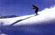 There are excellent ski slopes at Auli, Dayara Bugyal, Mundali and Munsiari. Auli, 16 kms from Joshimath has a winter resort run by the State government outfit, Garhwal Mandal Vikas Nigam (GMVN). The ski slope here is the most popular in the state and one of the few with ski lifts. The season starts from end December or January and extends up to March. This is a good place for beginners as GMVN conducts 7 and 14 days skiing courses at subsidised rates.
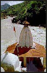 Rudrapayag, as the name specifies, is at the junction of two rivers, Alaknanda and Mandakini. It is situated on the route to Badrinath from Srinagar. From here the road bifurcates into two, one going to Kedarnath and other to Badrinath. This is a night halt for pilgrims and has many hotels and lodges. There is a small Jagdamba Devi Temple dedicated to Goddess Durga. There is also an old temple dedicated to Lord Shiva, Rudranath temple. Legend states that Narad Muni meditated here for several years in return for which Lord Shiva blessed him with his musical talent.
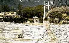 Tehri was the capital of the erstwhile princely state of Tehri-Garhwal. Maharaja Sudarshan Shah founded the town in 1803. Earlier to which Srinagar used to be the capital. The palaces and temples built by the old rulers can be seen.The Tehri Dam has come up on the river Bhagirathi and the project is estimated to generate 2400 MW of electricity.
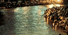 The name Haridwar means gateway to God, since this is the place where the pilgrimage to two famous temples Kedarnath (Lord Shiva) and Badrinath (Lord Vishnu) starts. It is situated on the banks of river Ganga at the foothills of Shivalik Mountains. Since time immemorial, this has been a place of meditation for sages and rishis. Sage Kapil meditated here and the place was once called Kapilasthan. Haridwar is one of the four places where Kumbh Mela is held every 12 years when millions of people take a holy dip in the river Ganges. It is said that the pitcher of Amrit (ambrosia) was kept in hiding here by the gods when it was unearthed from Sagar Manthan. In the struggle with Asuras (demons) the pitcher broke spilling some sacred water at 4 places, the others being Allahabad, Ujjain and Nasik. The Kumbh mela is held every 3 years in these cities in succession. A beautiful Arti is performed every evening at Har-ki-Pauri. There is a slab where the footprints of Lord Vishnu are believed to be imprinted. Places of interest s are Har-ki-Pauri, Ram Krishna Mission, Seva Ashram, Gurukul Kangri University, Sapta Rishi Ashram, Bharat Heavy Electricals Factory and the Mansa Devi Temple
 Almora is a hill district in the central Kumaon region of Uttarakhand. It is a beautiful scenic town situated at an altitude of 5900 ft. It was founded by Raja Kalyan of Chand Dynasty in 1560AD. There is a cave where Swami Vivekananda meditated and was enlightened. Almora was captured by British from Gorkhas, who have left their mark on this town. The Nanda Devi festival is celebrated here, during which devotees from all over India visit this place. Almora is very popular among tourists from nearby cities who come here during the summer for a holiday. There are very enchanting spots nearby such as Jageshwar, Binsar and Sitlakhet. The nearest railroad station is Kathgodam from where jeeps or bus have to be taken.