 Guides are essential and can be hired at Guttu. On occasion, trekkers will be walking heights of well above 5,200 m. The route is as follows: Khatling Glacier (3,658)- Chokital (3,658 m, 1.5 km) - Dudh Ganga Gufa (3,658 m, 3 km) - Masuri Tal (4,572 m, 10 km) - Paijan Tal/Teen Tal/Punya tal (5,629 m, 7 m) - Basukital (4,328 m, 6 km) - Kedarnath (3,581 m, 8 km). At Kedarnath there are guest houses, dharamshalas and a tourist bungalow.
Optional route two: Khatling Glacier (3,658 m) -Ratgaryan/Ruddugera South (3,962 m, 7 km) - Ruddugera Pass (5,639 m, 13 km) - Ruddugera North (3,658 m, 13 km)- Gangotri (3,048 m, 20 km). This trek requires mountaineering skills and adequate advance arrangements. Ruddugera Pass is snow bound. Camps can be set up at convenient places enroute. At Gangotri, stay in a tourist bungalow, forest rest house or PWD inspection house. From Gangotri, buses are available for Uttarkashi and on to Rishikesh.
 Route three
Tehri (600 m) - Chirbatia (2,134 m, 55 km) - Bishnoi Hill (2,896 m, 20 km) - Panwali Kantha (3,048, 20 km)- Badhani Tal (2,743 m, 20 km) - Mankha Khal (2,995m, 8 km) - Phatta (1,829m, 10 km). At Chirbatia, there is a forest rest house. For all other points enroute one will to have depend on shepherd's huts, and on one's own tents. There is a PWD inspection house at Phata, which is a big village. >From Phata one can take a bus for Gaurikund and visit Kedarnath, or take a bus to Rishikesh.
Base : Gwaldam
Gwaldam is a typically Himalayan village - a small market town surrounded by fruit orchards, an ideal base from where to go trekking. One can stay here in a tourist bungalow.
Route one
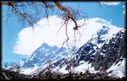
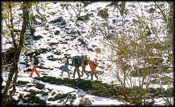
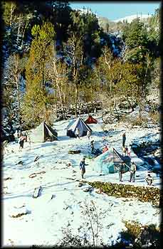 Gwaldam(1,829 m) - Debal (1,218m, 12 km)- Mundoli (2,100 m, 8 km) - Wan (2,400 m, 8km) - Bedini (3,354 m, 10 km)- Bhagwabasa (4,000 m, 9 km) - Roopkund (5, 029 m, 5 km) - Jyuragoti (5,000 m, 2 km) - Shila Samudra (3,658 m, 8 km) - Homkund (4,000 m, 5 km) - Sutole (9km ) - Ghat (26 km) - Nandprayag (19 km). This trek to the mysterious Roopkund, is memorable. Is was at Roopkund lake that a large number of human bones were found and anthropologists are still working on its significance. Once visited by Lord Curzon, then viceroy of India, the route was named Curzon Road after him. There is a forest rest house, tourist bungalow and dharamshalas at Debal, and tourist bungalows at Mundoli and Wan, which is also the last village on the route. Bedini, with its beautiful meadows, has a forest rest house and snow huts and a cave where one can take shelter. Beyond that, tents required for purposes of camping. Ghat is a roadhead, with a PWD inspection house, and buses are available from here to Nandprayag.
Route two
Gwaldam (1,829 m) - Debal(1,218 m, 12 km) - Manpata (1,372 m, 20 km) - Kheta (1,524 m, 15 m) - Harmol (1,829m, 20 km) - Khati (2,210m, 25 km) - Dwali (2,576m, 11km)Phurkia (3,261 m, 5km)-Pindari Glacier (3,353 m, 8 km). The Pindari Glacier trek is popular, for it allows strenuous trekking with fabulous views of the Himalayas, and is challenging both for the first-timer as well as more experienced trekkers. Debal has a tourist bungalow, in Manpata stay in a school building, and camp at Kheta and Harmol. There are PWD inspection houses at Khati, Dwali and Phurkia. From Pindari Glacier one can come back to Bageshwar and take a bus to Nainital.
Base : Joshimath
 A popular centre of pilgrimage, Joshimath has a tourist bungalow, hotels and dharamshalas. It is the base for trekking to the famous Valley of Flowers. The season here is short lived: it starts from mid-July and lasts till end-August.
Route one
Joshimath (2,100m)-Govindghat (2,000m, 18 km)-Ghangaria (3,000m, 12.5 km)-Valley of Flowers (3,300 m, 3.5 km). The trek begins at Govindghat, which has a forest rest house and a gurudwara. There is a small market at Ghangaria during season, and overnight accommodation is available in a tourist gurudwara. Please note that camping within the Valley of Flowers is not permitted.
Optional route: Hemkund, a centre of Sikh pilgrimage, can be reached from Ghangaria and is 5.5 km from there. The climb is steep. There is a lake at the top with a gurudwara by its banks. A Laxman temple is situated close to the gurudwara.
More Trekking Itineraries:
Garhwal - 1
Kumaon - I
Kumaon - II
More Trekking Articles