| Trekking
Valley of the Gods |
|||||
My adventure started from Calcutta when I boarded the Doon Express bound for Haridwar. After traveling through the heart of India, I reached Haridwar, the city of temples, at midday on the 1st of Aug. '98. My friend's apartment, where I spent the night, was adjacent to the Bharat Mata temple, one of the most ornate temples of Haridwar. It was the beginning of an intimacy with religion and with religious people that would be an integral part of this trip. After a day in Haridwar, it was time to go to Rishikesh. Rishikesh-the name itself evokes images of Rishis, and the experience was no different. On evenings, as I would sit by the Ganga, I would witness ancient Hindu rituals being carried out in a continuum of timelessness that can, perhaps, occur only in India. Here was an intermingling of the old and the new, the ancient and the modern, the rich and the poor, brought together by their belief in a cleansing process whose origins could be traced back for centuries. |
More on Uttarakhand • An Overview
Trekking
Adventure activities
| ||||
As one would sit and feel the cold wind
 blowing over the Ganga and watch the lamps being set alight on the water to appease the spirits of ones forefathers, even the most hardened atheist can't help but feel a tinge of spirituality. This was the Ganga, the river which for centuries had fed, influenced, nourished and nurtured India. I decided that I would retrace the route of the Ganga and then follow one of its tributaries, the Alaknanda, back to its source near Vasudhara Falls adjacent to Mana village. blowing over the Ganga and watch the lamps being set alight on the water to appease the spirits of ones forefathers, even the most hardened atheist can't help but feel a tinge of spirituality. This was the Ganga, the river which for centuries had fed, influenced, nourished and nurtured India. I decided that I would retrace the route of the Ganga and then follow one of its tributaries, the Alaknanda, back to its source near Vasudhara Falls adjacent to Mana village.
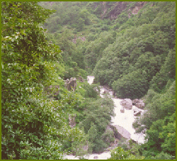
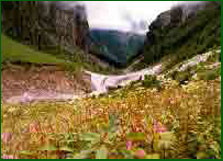
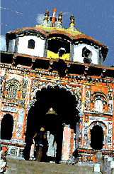
The next day at dawn we were off! We hurtled along serpentine roads with precipitous drops for quite a few hours till we reached Devaprayag. The first major Prayag, or confluence. It was here that the Bhagirathi and the Alaknanda came together to form the Ganga. We followed the Alaknanda and went through Rudraprayag (famous for Jim Corbett's exploits described in the "Man Eating Leopard of Rudraprayag"), Karna Prayag (confluence of Pindar and Alaknanda), Nandaprayag (confluence of Nandakini and Alaknanda) until we reached Pipalkoti. Everything was perfect. The weather was great, the sceneries were awe-inspiring and my companions were fun. Things seemed too good to last. Sure enough, at Pipalkoti we were informed that we couldn't reach our objective of Govindghat thanks to a landslide. We were lucky to be able to find some accommodation in a GMVN rest-house at Pipalkoti. The next day, our most demanding, would require all the mental and physical resources that we could muster. Landslide! The trek from Govindghat (alt 1,828 mts) to Ghangria (alt 3,048 mts) was one of the most popular treks of the whole journey. This is the same route that pilgrims take to go to Hemkund Saheb and because of this, there are ample villages en route from where one can buy food and water. Horses can also be rented but for those who want the freedom to just stand and appreciate the grandeur of the Himalayas, horses are definitely taboo. Horse droppings combined with drizzling rain made the path slippery and treacherous and it was dark before we could see the lights of Ghangria from a distance. En route, we were helped by numerous friendly Garhwalis who helped us to take short-cuts in the dark without which we would perhaps have had to suffer considerable hardship. The Valley of Flowers As this was a protected National Park, there are no villages in the valley and neighbouring villagers aren't allowed to graze their cattle here. This undoubtedly helps to keep the valley pristinely clean but this policy also has its drawbacks. Weeds, which previously used to be controlled by the goats, have recently become a problem. But nothing can retract from the sublime beauty of the Valley of Flowers. As I sat amongst plants about five or six feet tall and listened to the sounds of silence, I experienced a kind of ecstasy that city dwellers usually don't get to appreciate. The bountiful wild flowers, spread like carpets, with their myriad intoxicating smells cast a spell on me that was difficult to ward off and it was only the advent of rains in the afternoon that prompted me to start my return journey. Hemkund Saheb The scenery is exquisite with the clouds playing games and constantly changing the whole scenery every few minutes. One can stand for hours and appreciate the visual feast for hours as the first peak comes into view and then gets covered by clouds only to reveal yet another one. It is the ultimate natural slide show that leaves one mesmerized. The last half a kilometer is home to the elusive Brahmo Komol. This flower, which is perhaps the only Komol (lotus) to grow on land, features prominently in Hindu scriptures and grows in the wild only in high altitudes. Badrinath and Mana All along the trip to Badrinath, the Alaknanda river flowing below in a deep gorge kept us company. It was one of the most scenic stretches of our trip and it was a pity that we took a bus as it didn't leave us with much time to stand and stare at nature's bounties. Finally we reached Badrinath, which because of it's importance as a site of Hindu pilgrimage is a very modern town. With bustling shops and restaurants, Badrinath was quite different from our experiences of the previous few days. The ubiquitous pay-phone booths helped me to get back in touch with my family after a hiatus of four days. Neelkantha
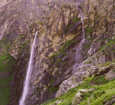
Finally after a light breakfast we headed for Mana. Mana is the last Indian village in this part of the country. Beyond the mountains behind Mana lies China. Our objective was to follow the Alaknanda, which by now had become a fraction of what it was at Devaprayag, to the Vasudhara Falls. This trek beyond Mana is not a very popular trek and yet is exquisite. One has to trek through glacial moraines and even a couple of glaciers before one can see the 145m Vasudhara Falls. We were lucky to have a bright sunny day and one could look at whole ranges of snow clad peaks in their pristine glory. This region has a very prominent place in Hindu mythology because this is the road that the Pandavas were supposed to have taken on their way to heaven. As suddenly as it had begun, my trek was finally over. The day after I returned to Dehra Dun, torrential rains started in the mountains. These led to landslides which came to be known as the Great Himalayan Landslide of 1998. Over 80 people were killed in Rudraprayag and another 200 in Malpa Village en route to Kailash. The Himalayas are pretty, very pretty, but they can also be merciless and who are we puny humans to stand in the way of the will of the mighty majestic mountains-the Himalayas?
(Photo Credit: Nandan Das)
|
|||||
Editor: Romola Butalia (c) India Travelogue. All rights reserved. |
|||||
 As would become our usual routine, we started after a light breakfast at dawn. Our backpacks on our backs, with a song in our hearts we were ready to conquer the world. All of our bravado was squashed when we saw our first landslide. It seemed as if the whole mountain side had moved down with a vengeance and had devoured everything that man had dared to put in it's path. We gingerly made our way across, constantly looking up to see if more rocks were on their way down. It was a good 9 km stretch that was interspersed with landslides, big and small, before we reached our destination, Helong. From here, we would take another bus to Govindghat and then we would need to walk a further 14 kms before we could find a place to spend the night.
 5th of August, we started at day break to trek to the Valley of Flowers (alt 3,658 mts) about 5kms away. This was off the beaten track for pilgrims and as I had started much earlier than the rest of my companions, very soon, I found myself completely alone amongst the majestic mountains. After trekking for about 4 kms, I descended into the Valley which is covered by glaciers for about 8 months of the year.
 For the last leg of the journey, we trekked down from Ghangria to Govindghat and then took a bus to Badrinath. Unfortunately, even this time our journey was interrupted by landslides near the village of Ram Bagri. In these areas, the roads are maintained by the Border Roads, which is a division of the Indian Army. It was amazing to see the conditions under which the brave army jawans of India work to get these vital communication links restored. I saw army men operating bulldozers with little or no concern about their own safety in what, to me at least, seemed rather inhospitable conditions. On our return journey from Badrinath, we were amazed to see that the road, although not completely repaired, was road-worthy!
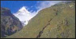 We got out of our beds at around 4 in the morning. It was a full moon night and apart from the soft light of moonlight peeking from behind the still rather heavy cloud cover, everything was dark. Neelkantha was still invisible. We were all sipping hot mugs of tea and trying to protect ourselves from the cold mountain air when suddenly at 4:30am, the clouds parted and out peeked the visage of Neelkantha gleaming like silver in the light of the moon! This sight which could only be recorded in my mind's eye was spectacular enough, but there was more to come. About 25 minutes later, the clouds came back to hide Neelkantha from our view once again. We were quite ready to go back inside, our desires fulfilled when suddenly around 5:30 a.m., Neelkantha came back in sight again. But this time, the peak was completely awash in a golden hue! The sun had come up at that altitude and even though the valley was still shrouded in darkness, Neelkantha's peak was glimmering in gold. These two mesmerizing views, juxtaposed in time was enough to make me fall in what is likely to be a lasting love affair with the mighty Himalayas.