| Trekking Freedom From Fear |
|||||
The other side of fear is freedom. It was not until the first reflections of sunshine off the white peaks of Khangchendzonga had set my soul soaring that I realised this, my senses numbed in stillness.
I was all alone on this venture. For the first time, I approached a trekking agent in Gangtok, recommended by a friend, to assist me in working out the logistics of the trip. At 8:30 a.m. on the morning of 12th April, I left Gangtok, to arrive at 4 p.m. at Yuksam, 142 kms away, as the dipping afternoon sun heralded the approaching evening. |
More About Sikkim • An Overview
Trekking
Adventure activities | ||||
At Geyzing, we changed jeeps to complete the last 24 kms on an unmetalled, but relatively comfortable road, replete with breathtaking views of mostly virgin West Sikkim. En route we passed Pelling, an upcoming tourist attraction, being developed with all the trappings of luxury and comfort at the expense of retaining it's natural splendour. Lamentably enough, Pelling had fallen victim to the creation of yet another honeymooner's paradise.
Next morning I met my companions who would guide and help me on my journey through the high Himalayas - Shankar Chettri, my Nepalese guide, and his compatriot, the handsome Bimal, who would be the cook-cum-porter. Breakfast done, we headed for the local police station to register our personal details and planned itinerary. In the event of the untoward, the onus of venturing deep into the wilderness to seek us out, lies with the police here. Only the previous evening, I had learnt about an elderly German doctor who had lost his life at Phedang from High Altitude Sickness. People from the police station had left to bring back his mortal remains.
Initially there was a problem registering our team as Indians, since none of us had valid papers to support our claim. The solution lay in inducting Deepak, who had the requisite papers, as the porter, while Bimal, with his culinary skills, was cook for the gang. Leaving behind the traces of the tyre marks of yesterdays jeep ride, we hit the trail at 7:40 a.m. Soon enough, we came to Paha Khoda, with a small suspension bridge over a stream. I was politely told by my gang to stop and wait. Why, I wondered ? They pointed to the top of the mountain across, where I saw a bulky baggage being transported down. It was the unfortunate German trekker. This one image remained etched on my mind throughout my mountain sojourn, to keep me somewhat nervous and a little perturbed.
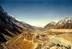
As I went deeper into the wilderness, nature unfolded itself to my awestruck eyes. I came across several species of plants, typical of this region of the eastern Himalayas. This entire area is part of the Khangchendzonga Wildlife Sanctuary, the world's highest, spanning close to a thosand square kilometres ranging from 6,200 ft to 28,156 ft, including Mt Khangchendzonga itself. The initial 10 kms of the trail is a moderate climb, leading to a long suspension bridge over Prek-Chhu (Chhu in Tibetan means water, and when associated with a name, refers to a river). From here, begins the real workout. Whereas the first 10 kms took three and a half hours, the remaining six took four and a half hours of strenuous climbing.
I learnt that the German had lain here 2 days after meeting his end in the remote Himalayas. This knowledge only added to the already eerie silence and somehwat unearthly ambience of Phedang. After a brief rest of 15 minutes, preoccupied with thoughts of the fate of a fellow traveller on the trail, we walked the remaining four, seemingly endless, kilometres.
In Tibetan, 'rii' means mountain and 'zong' means collection. In Bhutia, 'zong' means home, or a place where people meet. As I see it, the nomenclature of Dzongri must have been influenced by it's geography. Located in what appears to be a valley, Dzongri is more like a huge amphitheatre encompassed by small and large ranges. Here, many trekkers spend a day or two before proceeding back on the return journey. However, from here, one route goes westwards towards the Rathong glacier, and further west, into Nepal, while another route goes east to Goecha-La. On a clear day, the early morning views of the surrounding peaks are a splendid sight. At Dzongri, we had a spell of torrential rain that metamorphosed into a light snowfall in the early evening. The following morning, 15th, we woke to clear skies and the stunning grandeur of brightly sunbathed ridges all around. The unique character of the terrain, with it's spell-binding landscape of a random assortment of high and low ranges running into each other, is a visual delight.
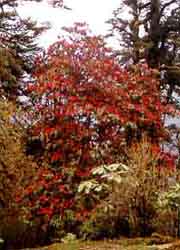
Dzongri is a landmark on this major trekking route. For many, it is the culmination of their journey. For others, it marks the point where the terrain changes character. Unlike the past two days of gruelling elevations, the journey onwards is a moderate climb through stretches of abundant rhododendrons in final bloom that is an explosion of colour on nature's canvas. The four km walk ahead leads to the trekkers' hut at Kokchhurung, on the western bank of the river Rathong, generally used as a night halt on the return journey from Goecha-La. Here, a small wooden bridge over the river leads to lunch at Thangshing at 12,600 ft.,a valley at the foothills of a range that boasts three highrises, Mt. Pandim at 22,281 ft, Tenzingkhang at 21,000 ft and Narsing at 20,500 ft. From here, we walk with these peaks on our right and the Khangchendzonga range at a respectful distance on our left.
At 3 in the afternoon, 6 kms from Thangshing, we reach the trekkers' hut at Smiti lake. At 14,200 ft, this is a molten glacier of Mt Pandim and the source of the river Rathong, meaning the turbulent one. An inhospitable fierce freezing blast at 45/50 miles an hour greets us. Apparently, this is a round-the-clock, through-the-year phenomenon, accompanied by intense snowfalls in the afternoon or evening and perenially sub-zero temperatures with wind chill factor to boot.
Goecha-La (in Tibetan, " La " means mountain pass) at about 17,000 feet is about 6 kms from Smiti.On 16th morning, I set off with my guide for the final walk up.Within half an hour we were beyond the tree line.With vast mountain tracts strewn with rocks and boulders and desolate stretches of harsh barren landscapes of sandy terrain, I was reminded of the fact that the Himalays once lay in the ocean. All the glacial beds that I walked across were nothing but stretches of sand, white or greyish white in colour. It is impossible to describe the still silence and the ethereal ambience of the high Himalayas.
|
|||||
Editor: Romola Butalia (c) India Travelogue. All rights reserved. |
|||||
 They say that before you embark on an awesome task, keep two things in mind. Firstly, ignore the world that attempts to discoursge you. I paid no heed to the refrain, "Going up alone? Are you sure?" Secondly, if you are persistent enough, You Can Make Dreams Happen. So I desperately sought the strength I would need to keep my spirits high.
 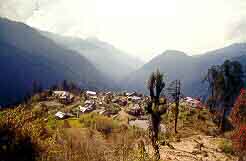 I checked into one of the few available hotels at Yuksam. Wooden, stone and slate constructions dotted the village, a few hundred strong, predominantly Nepalese earning their living as guides, porters and cooks. Yuksam literally means the meeting place of three wise men. During the early seventeenth century, as recorded by the Sikkim Gazeteer, Lhatsun Chembo Namgyal from Tibet, on the north, met two unnamed lamas from the west and south to fulfil a prophecy according to which they invited a learned young man from the east, Phuntshog Namgyal, who was crowned the first Chogyal (Dharma-raja or religious king) of Sikkim in 1642. Beside the pagoda like construction that houses and preserves his throne, is a footprint embedded on the ground, that legend claims belongs to the Lord Buddha.
 At Bakhim, at 9,000 ft, 14kms from Yuksam, is a forest rest house where I met a family visiting India from London, on their way down from Dzongri. Over a cup of steaming tea and mouth-watering pakodas, I was drawn into an interesting chat, until at 5 p.m., I realised that I had to move on before it became totally dark. Two gruelling kms to go, but after the refreshing breather, I made it in 42 minutes, reaching Tshoka, pronounced Chhoka, as darkness enveloped the surrounding mountains. At 10,000 ft, with 15 households and a headcount of some 55 Tibetan refugees settled here, this circular flat ground with steep cliffs on three sides, is the last habitation en route. I must have been lucky. As I stepped into the trekkers' hut, the skies unleashed a deluge of pouring rain as though the end of the universe was at hand. The rain continued well into the night, only to be transformed to a bright morning of perfect sunshine. Tshoka, being the only major night halt on the upward climb, and the last on the return journey, is always crowded. To get a room at the trekkers hut here, which accommodates about 24 people, is a matter of luck. Alone in my room, I luxuriated in this rare pleasure.
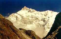
 We still had a day's journey ahead to reach our destination. Starting the day at 7:45 a.m., we walked uphill, keeping the trekkers hut directly behind us, reaching the crest of the mountain where Dzongri is. The entire horizon was suffused with the reflection off the peaks, which were illuminated an irridescent white. There ahead of us were the mighty peaks of Rathong, at 22,242 ft on the extreme left, followed by Kabru South, 24,366 ft, Kabru North, 24,436 ft and a part of the Khangchendzonga, visible on the right. Mt. Khangchendzonga is the third highest peak in the world. Legend has it that the five peaks represent the tiger, lion, elephant, horse and garuda.
 At 9:30 a.m. I was on my back, stopping briefly at Smiti for lunch that I was coaxed into eating, and had to literally force down my gullet, having totally lost my appetite. After a night halt at Kokchhurung, we reached Tshoka by a different, longer route, bypassing Dzongri. I seemed to be compelling myself now to race back in a manner driven, such that evening found me like the walking dead along the main thoroughfare of Yuksam. A day spent unwinding at Yuksam, and on 19th morning, I was promising myself, with total commitment, to return again, as my jeep roared round the bends of Yuksam, leaving behind a cloud of dust.