| Trekking Satopanth Tal: Route to Heaven |
|||||
According to Hindu mythology, Satopanth Tal is on the route taken by the Panch Pandavas on their Swarga Yatra. At various places their name remains as a memorial of this sacred journey. At the starting point at Mana, 3 km away from Badrinath, is the natural rock bridge, Bhima Pul. Here, Bhima is believed to have made the bridge over the river Saraswati so Draupadi could cross. At Lakshmi Ban, Draupadi is believed to have breathed her last. In the austere barren landscape at an altitude of 12600 feet, strewn with huge boulders, bhuj plants grow in the small patch of Lakshmi Ban. At Bandhar, it is said that Yudhishthir's thirst was quenched by the baan or arrow shot by Arjun which caused a stream of water to gush forth from the very Earth. At Bhimbar, the rock pillar commemorates Bhima's release from earthly life. At Chakratirtha the great yogi and warrior, Arjun gave up his body. Ahead, only Yudhishthir with his dog, who was indeed Dharma Raja himself, went in his mortal form, negotiating dangerous glaciers and hidden crevasses. At Satopanth Tal, the celestial rath or vehicle received him. |
More on Uttarakhand • Overview • Char Dham
Trekking
Sacred Space
Travelogues
| ||||
With us were high altitude guide Devendra Rana of Joshimath, who has accompanied expeditions to various Himalayan summits in the Himalayas. The rest of the team, all from Joshimath included Dilawar Singh Rana, one of the most able porters. Surendra Singh Rawat was the oldest and most experienced porter. Harendra Singh Rawat was the youngest which was compensated by his enthusiasm and good cheer.
This trek generally takes 5 days. We scheduled an extra day staying overnight at Satopath. The trek begins at Mana, 10500 feet, 3 Km from Badrinath. Lakshmi Ban to Bandhar (13000 feet) 2 Km. Bandhar to Shahasra Dhara (14000 feet) 4 Km.
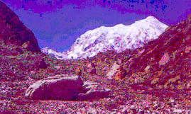
At ancient Badrinath, where Sri Narayana is worshipped in the holy temple, revered by all Hindus, people come for darshan from across India and from abroad. The temple opens in April on Baisakhi and closes the day after Dipawali. The chilly winds and near zero temperatures at Badrinath, combined with the fact that we would begin early on the trek the following day, called for an early night. We woke up to our first view of Mt. Neelkanth (21638 feet) between Nar and Narayan Parbat from our window in the Hotel. The first lights of the sun glowed on the tip of the peak and we watched in awed as the colours changed on the mighty snow peak.
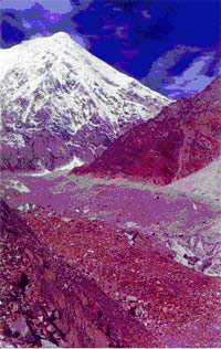
The next day was expected to be a hard day as we planned to cover the additional distance of the previous day's shortfall to reach Chakratirtha in the evening, as scheduled. We woke early but because the valley is inside towering mountain walls, we had to wait for the sun to dry our tents. At nine am we walked along trackless paths and over large bouders. While approaching Lakshmi Ban, just opposite the Banglung Glacier snout point at Alkapuri from where the river Alkananda originates, we got the entire view of the great glacial area. At Lakshmi Ban we saw Bhuj Plants that grow in the Himalayan region at altitudes over 10000 feet. In ancient days, the leaves of the bark of these plants were used for manuscripts. At Bandhar we got the first view of the Bhagirathi Kharak Glacier which emerges from Mt. Bhagirathi I, II & III and continues to meet the Banglung Glacier at Alkapuri. Mt. Bhagirathi I (22488 feet), II (21359 feet) & III (21169 feet) are visible from here. From Bandhar upto Sahashradhara the path was entirely over boulders strewn over a narrow ridge. By the time we reached Sahashradhara at 2:30 pm, the weather was rapidly deteriorating, as it is wont to do in the late afternoons. We decided to pitch our tents at the bank of a narrow stream. As it was not a proper camping site, the wind at this altitude of some 14,000 feet was harsh and biting cold. Most members were feeling the ill-affects of high altitude. The west face of Mt. Neelkanth (21638 feet) was visible from here. From Badrinath we can view the East face. Icy winds blew through the night and it was biting cold. As is often so at higher altitudes, we could not sleep properly. We awoke to the thick layer of fresh snow on the narrow stream beside which we pitched our tents. There were footprints which some claimed are the rare snow leopard believed to be occasionally sighted in these regions.
We started at 9 a.m., climbing long distances over boulders, short of breath and stamina, keenly aware of the scarcity of oxygen in the air. As we approached Chakratirtha, the wide view of the snow capped peaks opened, one by one. We had our first view of Mt. Parvati & Mt. Satopanth (23206 feet) along with the others, previously seen. The sacred lake, Satopanth Tal, lies below Mt. Satopanth (23206 feet). We reached Chakratirtha at about 12 noon to snack on our supply of dry foods, hoping to continue upto Satopanth Tal, but some members reached after 1 p.m., so we decided to camp at Chakratirtha. The valley at 15,000 feet has a large grassland and we basked in the afternoon sun, here. We witnessed terrifying avalanches off Mt. Satopanth (23206 feet) & Mt. Parvati and heard the gigantic sounds of glaciers breaking. Quite suddenly the sun vanished and it was entirely white, far in the distance. The snowfall which started at about 3 p.m. did not last long. The next day we walked from Chakratirtha to Satopant Tal. It was Ekadasi, when it is believed that Lord Narayana Himself bathes in these sacred waters. Climbing diagonally up a rocky sharply inclined wall face, it took us about an hour to reach the top of a ridge. Climbing down the precipice-like slope was very dangerous. From here the entire region of sheer glacier was visible. We watched crevasses in the valley. It was impossible to make out the way through the valley. Our able guide, Devendra Rana, along with his porters, worked a way down to the moraine or small rocks lying over old glacier. This work was done with an ice axe. The path was constructed diagonally by the wall of the ridge and required careful maneuvering. From here till Satopanth Tal we had to walk over the unseen glacier. At some places the glaciers was visible as the layer of boulders had moved away due to avalanches. We followed the route by the markings previously laid down of rocks placed vertically one on top of the other, at various places over the glacier. These markings by passing guides denote the tried path to Satopanth Tal. We moved up slowly and steadily, one by one, negotiating dangerous crevasses. At last we saw the welcome flag at the top of a ridge. Below the flag on the other side of the ridge is Satopanth Tal. By this time we were all exhausted. Scarcity of oxygen had slowed us. The last 1 km was much tougher, as we were moving through avalanche zone. Ultimately, one by one we came up at the bottom of the last ridge. Here the rocky soil was very slippery and the gradient of the ridge was also steep. Everyone kept calm and we succeeded in reaching the top of the ridge at 12 noon.
At Satopanth Tal there is a room which had been constructed by a pilgrim from the South. This room is still used by visiting sadhus and trekkers alike. In the morning darkness still enveloped us till quite suddenly the first rays of sunlight bathed the tip of Mt. Chaukhamba. Then started the fantastic colour changes on the snow. Initially pink, the colurs turned to shades of vermillion, red, orange, ochre and yellow until the sunlight shed its radiance on the entire region. Every one of us stood still in awe the half hour and more that nature revealed its finest hour of morning glory. We stayed at Satopanth Tal till 9 a.m. before we began our return trek to Badrinath via Mana. Stopping for lunch at Chakratirtha we reached Bandhar by the same route we ascended. The next morning we began our last days trek to Mana at 8:30 a.m. Having lunch opposite the Vasudhara, we continued on to reach Mana at 2 p.m. From here we took a jeep to arrive at Badrinath at 3 p.m. Here we offered our Pujas to Sri Badri Narayan before traveling to Haridwar where we spent a couple of days before boarding our train for Calcutta. Departing from the Himalayas, invariably one offers silent farewell to these mighty sacred mountains, and it seems they reply to return again. How blessed we are to belong to Bharat, where we can so easily reach the abodes of the Gods.
Photo Credit: Sumit Chatterjee
|
|||||
Editor: Romola Butalia (c) India Travelogue. All rights reserved. |
|||||
 Inspired by this ancient heritage and the lofty Himalayas, the playground of the Gods, our trekking club, undertook this sacred yatra. There was Sukamal Ray, 55, the most experienced trekker, a school teacher by profession and hence called Sir by all. Of equal age, was Bhabani Ranjan Ray, known as Bhabani da, an amateur photographer par excellence who loves the interior Himalayas. His wife, Avery Ray, Boudi, some 40 years of age, has a cheerful positive presence, and has accompanied him on all treks since they got married. Abhijit Chatterjee, called Bilas Da, also 40, is in the insurance business. An able trekker and decisive team leader he is a regular trekking partner of Sir. Indrajit Banerjee, 33 is in the furniture business. A keen trekker, he is a rational decision-maker and cool-tempered. Soumitra Bhattacharya, 31 works for Emami Pvt. Ltd and is enthralled by the Himalayas. The final twosome, is my wife, Bananai, 27, who was on her first trek, courageous and with firm faith, and I, Sumit Chatterjee, 33, working for Texmaco Limited. Apart from a natural affinity with the Himalayas, where I return at every opportunity, I am keenly interested in documenting my travels.
 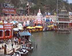 We arrived at Haridwar in the evening. At 4:30 am the next morning we left to cover the 320 Km distance to Badrinath, reaching at 6:30 in the evening. This is an incredibly beautiful route through the Garhwal Himalayas, crossing the 5 important Prayags or conjunctions of rivers. The route starts from Haridwar beside the river Ganga and passes Dev Prayag, where the river Bhagirathi from Gomukh, the snout of Gangotri Glacier joins the Alkananda. The river Mandakini comes down from Chorabali Tal behind Kedarnath to meet river Alkananda at Rudra Prayag. The river Pindar also known as Karna Ganga comes down from Pindari Glacier to meet the Alkananda at Karna Prayag. The river Nandakini comes from Mt. Nanda Ghunti to meet the Alkananda at Nanda Prayag. The river Dhauli Ganga comes from Mt. Dhaulagiri to meet the Alkananda at Vishnu Prayag. En route to Badrinath, we pass these five sacred Prayags.
 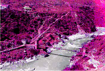 Our first days trek was from Mana to Chamtoli. The pre-arranged guide and porters reported on time. We had planned on leaving at 8 a.m. but had to wait because of a new regulation for trekkers to Satopanth Tal. As this area is close to the Indo-China Border, we needed a permit from the DM's office at Joshimath. Necessary permission is only issued after verification of Indian Citizenship on producing a valid Photo Identity Card. Our able guide cum High Altitude porter, Devendra Rana, who was familiar with the route also knew the officer-incharge at Mana ITBP (Indo-Tibet Border Police) check post. After considerable argument we were given permission on producing a written application stating that all responsibility for any mishaps on the Satopanth Tal route were squarely ours.
 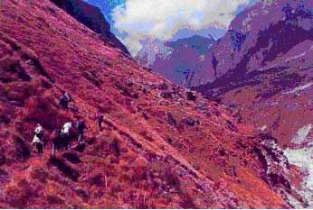 We finally started our trek at 11 a.m. Unlike the mythological route, we had to cross the river Alkananda at Mana by a rope bridge. We were walking along the right bank of the river till we reached a landslide zone. This area was at least half a kilometre and has to be covered without taking any rest in between. Every now and then rock pieces fell from the top on our left. We had to cross the area cautiously yet rapidly. On our right side the raging waters of the Alkananda flowed downstream. Thereafter, we had to climb a loose boulder wall of some 500 feet having a gradient of at least 75 degrees. This was a tiresome haul on the first day. Ahead, the path till Chamtoli was reasonable. Though we had planned on a night halt further on at Bandhar, the mornings delay saw us pitching tent at Chamtoli at 3 p.m. This is a beautiful green flat valley just opposite the well-known waterfall Vasudhara, in memory of Rishi Vyasa Dev. Looking back towards Mana Pass, the snow-capped peak of Mt. Kuber is visble among other peaks.
 It was a clear morning and we were mesmerized by the spell-binding views of the snow capped peaks of Mt. Neelkanth (21638 feet), Mt. Chaukhamba (23413 feet) and Mt. Balakun (20040 feet). As this place was behind Mt. Neelkanth (21638 feet) in the east, we had the same problem of not getting sunrays early in the morning. We also waited for the chilled wind to stop.
 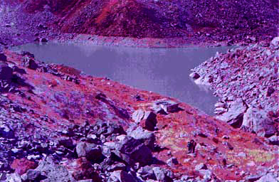 Here we had a magnificent view of the Lake: Satopanth Tal. It is a triangular shaped lake with each side about 1 Km. long. The crystal clear water had a greenish colour and all around the lake stands mighty Himalayan snow peaks. From left to right, they are Mt. Neelkanth (21638 feet), Mt. Satopanth (23,206 feet), Mt. Swargarohini (20507 feet), Mt. Chaukhamba I (23413 feet) and Mt. Balakun (20040 feet). As we came down at the bank of the lake we saw the reflection of Mt. Chaukhamba on the water. It was beautiful beyond expression. We offered worship, both silent personal prayers and puja to Lord Bramha, Vishnu & Maheshwar, breaking a coconut and also preparing a 'sinni'. Soon after the snowfall which began at 1:30 p.m. continued till late midnight.